Unitsset-up
Youcanspecifyyourpreferencefortheunitsofmeasurementthatwillbeusedinallapplications.
MenuitemDescriptionOptions
DistanceUnits
Theunitsofmeasurethatwillbeusedinall
applicationsforthedisplayofallvaluesrelated
todistance.
•NauticalMiles
•NM&m(Nauticalmilesandmeters)
•StatuteMiles
•Kilometers
SpeedUnitsTheunitsofmeasurethatwillbeusedinall
applicationsforthedisplayofallvaluesrelated
tospeed.
•Knots
•MPH(MilesPerHour)
•KPH(KilometersPerHour)
DepthUnits
Theunitsofmeasurethatwillbeusedinall
applicationsforthedisplayofallvaluesrelated
todepth.
•Feet
•Meters
•Fathoms
TemperatureUnits
Theunitsofmeasurethatwillbeusedinall
applicationsforthedisplayofallvaluesrelated
totemperature.
•Fahrenheit
•Celsius
GPSSet-upmenu
TheoptionsavailablefromtheGPSset-upmenuare
shownbelow.
MenuitemDescriptionOptions
ViewSatellite
Status
DisplaystheGPS
statuspage.
COG/SOG
Filter:
Refertothe
COG/SOGFilter
sectionfordetails.
•Low
•Medium(default)
•High
RestartGPSSelectingRestart
GPSwillrebootthe
internalGPS.
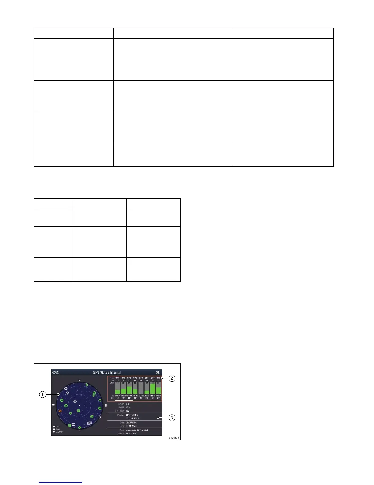
GPSStatus
ProductswithaninternalGPSreceiverorGNSS
(GPS/GLONASS)receivercanusetheGPSstatus
pagetoviewthestatusoftheavailablesatellitesthat
arecompatiblewithyourreceiver.
Thesatelliteconstellationsareusedtopositionyour
boatintheChartapplication.Youcansetupyour
receiverandcheckitsstatusfromtheGPSSet-up
menu.Foreachsatellite,thescreenprovidesthe
followinginformation:
1.Skyview
2.Satellitestatus
3.Positionandxinformation
Skyview
Skyviewisavisualrepresentationthatshows
thepositionofnavigationsatellitesandtheirtype.
Satellitetypesare:
•Circle—Acircleidentiesasatellitefromthe
GPSconstellation.
•Square—Asquareidentiesan(SBAS)
differentialsatellite.
•Diamond—Adiamondidentiesasatellitefrom
theGLONASSconstellation.
Satellitestatusarea
TheSatellitestatusareadisplaysthefollowing
informationabouteachsatellite:
•Type—Identieswhichconstellationthesatellite
belongsto.
•ID—Displaysthesatellitesidenticationnumber.
•CNO(Carrier-to-noiseratio)—Displaysthesignal
strengthofeachsatelliteshownintheSkyview:
–Grey=searchingforsatellite
–Green=satelliteinuse
–Orange=trackingsatellite
•AzimuthandElevation—Providestheangleof
elevationandazimuthbetweenthelocationofthe
receiverandthesatellite.
Positionandxinformation
Thefollowingpositionalandxinformationis
provided:
•HorizontalDilutionofPrecision(HDOP)
—HDOPisameasureofsatellitenavigation
accuracy,calculatedfromanumberoffactors
includingsatellitegeometry,systemerrorsin
thedatatransmissionandsystemerrorsinthe
receiver.Ahigherguresigniesagreater
positionalerror.Atypicalreceiverhasanaccuracy
ofbetween5and15m.Asanexample,assuming
areceivererrorof5m,anHDOPof2would
98
Dragony–4/Dragony–5/Dragony–7/Wi–Fish
 Loading...