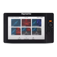
7.1 Chart app overview
The Chart app displays a representation of your vessel in relation to land masses and other charted
objects, which enables you to plan and navigate to your desired destination. The Chart app requires
a GNSS (GPS) position fix in order to display your vessel at the correct location on a world map.
For each instance of the Chart app you can select which electronic cartography you want to use.
The selection will persist over a power cycle.
1
Vessel icon
This icon represents your vessel, only displayed when a GNSS (GPS) position fix is
available. The icon is replaced with a Black dot if no heading or COG data is available).
2
COG line
If Course Over Ground (COG) data is available, you can display a COG vector for your
vessel.
3
Destination waypoint
During a go to, this is the current destination waypoint.
4
Waypoint
Use waypoints to mark specific locations or points of interest.
5 Databoxes
Databoxes display key information that is available on your system. You can configure
which data is shown in each databox or the databoxes can be hidden.
6
Destination line
During a go to
, a dashed line connects your vessel to the destination point.
7 Track
You can record the passage your vessel takes using Tracks.
8
Route
You can plan your route in advance by creating a Route using waypoints to mark each
route leg.
9 Chart range
Identifies the scale for the displayed chart range.
74

 Loading...