6.Dynamiccurrentgraphic—A
vailablewhenusingNavionicscartography.
Note:
Thedataprovidedinthetideandcurrentgraphsandgraphicsisfor
informationpurposesonlyandmustNO
Tberelieduponasasubstitutefor
prudentnavigation.Onlyofficialgovernmentchartsandnoticestomariners
containalltheinformationneededforsafenavigation.
Usinganimationcontrols
Theanimationcontrolscanbeselectedusingthe[Directionalpad]and[OK]
button.
WithcartographycontainingtidedataselectedintheChartapp:
1.Selectthe[TIDES]modeiconfromthemenu.
2.Select[Animatetides]fromthemenu.
3.Usethe[OK]buttontostartandstopplayback.
4.Usethe[L
eft]buttontoskipbackwardsthroughtheanimation.
5.Usethe[Right]buttontoskipforwardsthroughtheanimation.
Note:
Pressingandreleasingthe[L eft]or[Right]buttonswillskiptheanimationin
15minuteintervals.Pressingandholdingthe[Left]or[Right]buttonswill
skiptheanimationcontinuously,untilthebuttonisreleased.
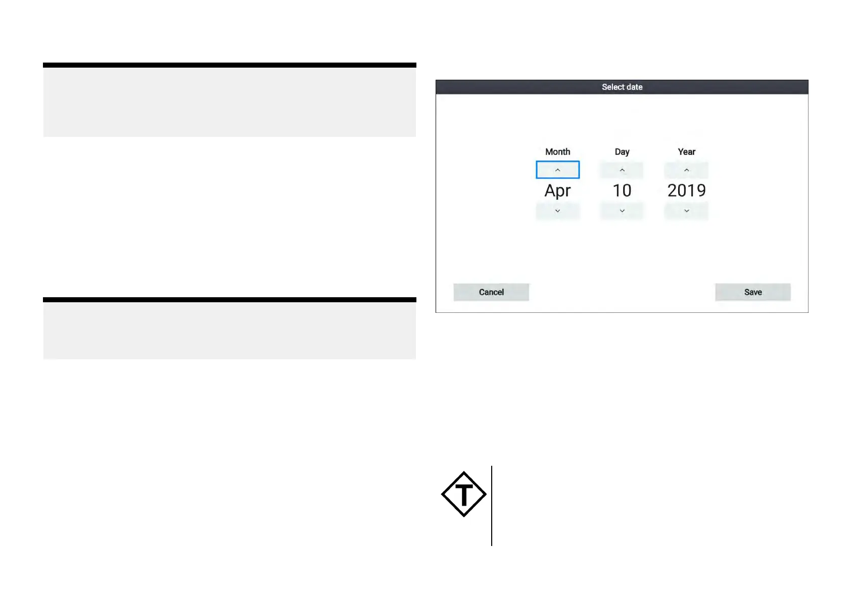
Selectingadatefortideanimations
Y
oucanselectaspecificdatefortideandcurrentanimations.
1.Select[Selectdate]fromthemenu.
2.Usethe[Left]and[Right]buttonstoselectthemonth,dayoryear.
3.Usethe[Up]and[Down]buttonstohighlightthe[Up]or[Down]arrows
4.Usethe[OK]buttontochangethehighlightedvalue.
5.Select[Save].
Tidestationinformation
Dependingonyourcartography,Tidestationinformationmaybeavailable.
Tidestationsymbol
ThelocationofTidestationsismarkedonthechartusinga
diamond-shapedsymbolwitha‘T’inthemiddle.
•ThesymboliscoloredRedwhenusingNavionicscartography.
•ThesymboliscoloredBlackwhenusingLightHouseCharts
orC-Mapcartography.
Chartapp
83
 Loading...