IFD500 Series Pilot Guide
SVS Subsystem 2-1
2 SVS Subsystem ‡
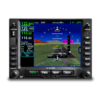
The Synthetic Vision System (SVS or SynVis) subsystem
consists of a single page to aid in the pilot’s awareness of their
spatial position relative to the terrain.
SVS uses a GPS-based MSL altitude and a 9 arc-sec terrain
database to display a 3D scene representing an “egocentric” out-
the-window view. The SynVis scene can display:
Total Velocity Vector (TVV) / Flight Path Marker (FPM)
Airport flags
Runway depictions
3D terrain
3D traffic
3D obstacles
Large bodies of water (oceans, lakes, major rivers)
The SVS page can also show attitude indications that overlay the
background depiction.
SVS computes height above terrain via GPS inputs and is not a
radio altimeter (RADALT).
Terrain Awareness and Forward Looking Terrain Alerting (FLTA)
alerts are provided via terrain coloration, Caution-Warning
Alerting System (CAS) alerts, and aural alerts. SynVis also
allows for a pilot-selectable horizontal field of view ranging from
20 degrees to 120 degrees with a 45 degree default.