AIR_Manual_506a_ENG_rev_1.pdf Page 23/96
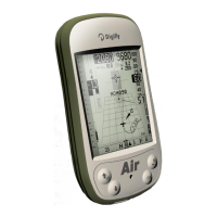
• The GPS icon signal has different meanings:
o Static GPS icon = Correct GPS FIX (GPS position available)
o Blinking GPS icon = poor GPS signal (valid GPS position NOT yet AVAILABLE)
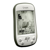
LATITUDE & LONGITUDE COORDINATES
The latitude and longitude coordinates are shown on top, referenced to map datum WGS84.
LATITUDE & LONGITUDE COORDINATES OPTIONS
There are 4 different coordinate formats available, to choose from:
= degrees, minutes and seconds (dd° mm’ ss.s) - default
= degrees and minutes (dd° mm.mmm’)
= Universal Transverse Mercator (utm x, y, zone).
= decimal degrees (dd.ddddd)
To set the preferred DMM, DMS, UTM or DDD formats, go to: MENU \
ADVANCED SETUP \ n. 23 CORD.
GPS SIGNAL QUALITY (HDOP)
The HDOP value represents the weakening of GPS signal; lower values mean good precision.
GPS altitude (“ALT GPS”) represents the height over sea level given by the GPS system.
GPS direction (“TRK”) represents the aircraft’s direction relative to the ground.
The GPS ground speed is the aircraft’s speed relative to the ground (“Gs”).
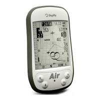
REAL TIME NAVIGATION MANAGER / SKIP WAYPOINT
The central part of the GPS INFO page shows the navigation progress of an active route in real time; you see the
waypoint list of the active route, where the current waypoint is highlighted in "reverse" (white over black).
In case navigation to a single waypoint is active, the central part of GPS
page will show only the name of
the current waypoint.
The "
" function allows you to choose to navigate to a different waypoint (previous or next):
Only from the
page, with an active route,
the button; the list will appear, press the
button to jump to the previous Waypoint or press to jump to the next Waypoint. Press to cancel.
The Digifly AIR also has a shortcut for the “Skip Waypoint” function, from any of the navigation pages. In order to
activate it, the "
"
parameter
(ADVANCED SETUP \ n. 24 SKPW
)
needs to be activated.
that this will change the functions of some buttons:
With the parameter set to
= Shortcut disabled (default),
the “ARROW DOWN” button changes
the volume level and
of the “OK” button sets the A2 altimeter to zero.
However, with the parameter set to
= Shortcut enabled and, when a route is activated both for competition
or XC,
the “ARROW DOWN” and “OK” buttons, will respectively work as skipping a waypoint back
and forward buttons, without having to go to the Info GPS page first.