149
Commands
Output standard GGA message.
$PASHS,GGA,STD
$PASHQ,GGA,[c1]
This command allows you to query the GGA position message, where c1 is the
optional port designator for the output of the response. If a port is not specified, the
receiver sends the response to the current port.
$GPGGA
This message is not output unless positions are being computed. In addition to a
3-D position (latitude/longitude/altitude), the GGA message contains information
on the type of position fix (i.e., autonomous or differentially corrected), HDOP, and
current time. The G12 can be set to output the GGA message at regular intervals
by using the command $PASHS,NME. The message is output in the format:
$GPGGA,m1,m2,c3,m4,c5,d6,d7,d8,f9,c10,d11,c12,d13,d14*hh
Table 4.74 defines the message format.
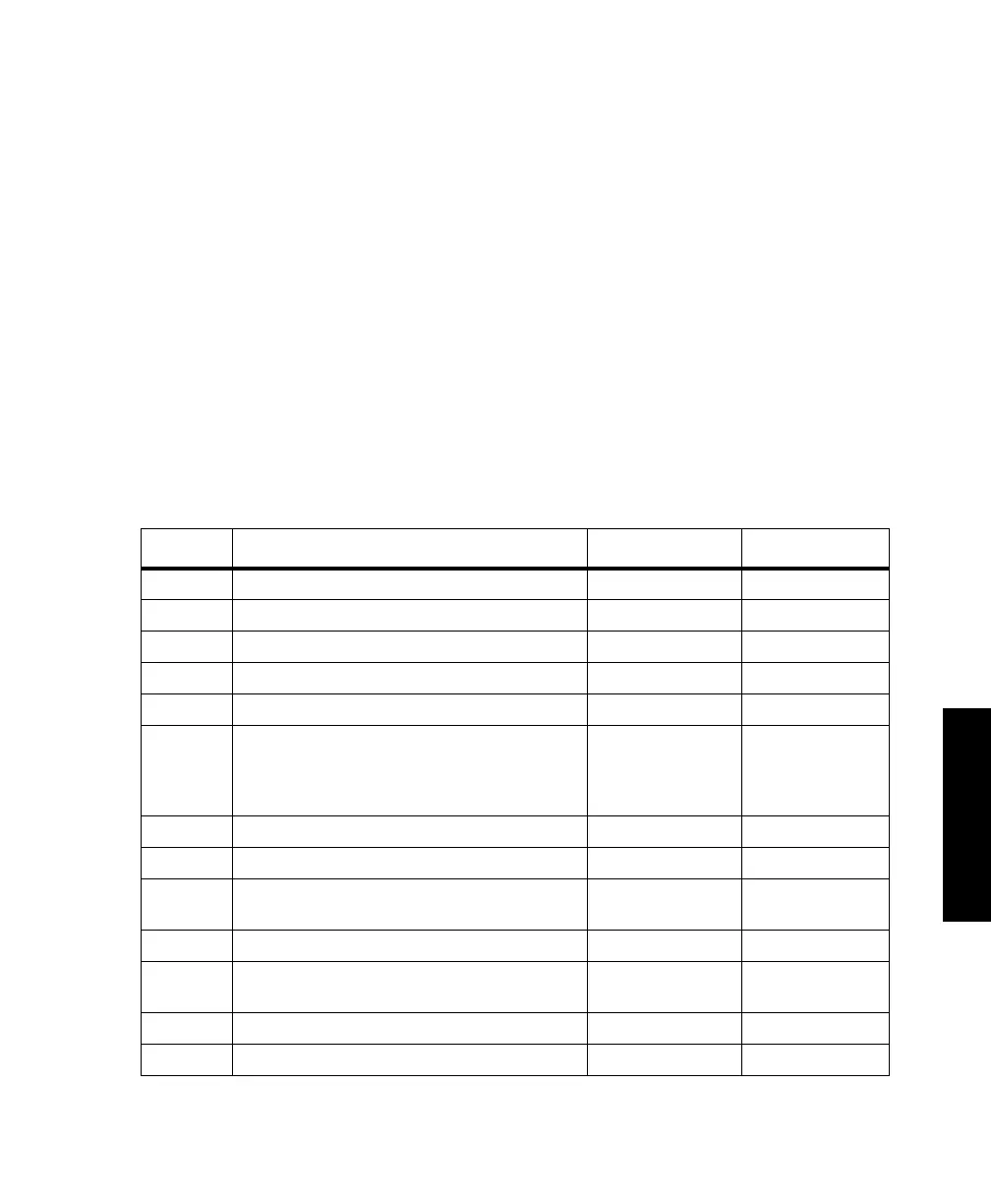
Table 4.74. $GPGGA Message Format
Parameter Description Range (FUL) Range (STD)
m1 UTC time (hhmmss.s) of the position fix 0 to 235959.99 0 to 235959.99
m2 Latitude of the position fix (ddmm.mmmmm) 0 to 9000.000000 0 to 9000.000000
c3 Latitude sector N/S N/S
m4 Longitude of the position fix (dddmm.mmmmm) 0 to 18000.000000 0 to 18000.000000
c5 Longitude sector E/W E/W
d6 Position fix type:
• 0 - Invalid position or position not available
• 1 - Autonomous position
• 2 - Differentially corrected position
‘0’/’1’/’2’/’3’ ‘0’/’1’/’2’/’3’
d7 Number of satellites used in position computation ‘3’ -’24’ ‘3’ -’24’
d8 HDOP (horizontal dilution of precision) ‘00.0’ -’ 99.9’ ‘00.0’ -’ 99.9’
f9 Altitude above Mean Sea Level (geoidal height) ‘-1000.00’ to
‘18000.00’
‘-1000.00’ to
‘18000.00’
c10 Altitude unit of measure (always M) ‘M’ ‘M’
d11 Geoidal separation value ‘-999.999’ -
‘999.999’
‘-99’ - ‘99’
c12 Geoidal separation unit of measure (always M) ‘M’ ‘M’
d13 Age of differential corrections (seconds) ‘0’ - ‘999.999’ ‘0’ -’99’
G12RevD.book Page 149 Tuesday, April 2, 2002 4:33 PM