3-SETUP
Azimuthandelevationareanglesusedheretodenethe
positionofasatelliteintheskyrelativetothevehicle.
Theazimuthangleisthecompassbearingonthehorizon,
relativetotruenorth,ofapointdirectlybeneathasatellite.
Compassbearingsaremeasuredclockwiseindegrees
fromnorth.Azimuthanglesrangefrom0°(north)through
90°(east),180°(south),270°(west),andbackto360°
(northagain).
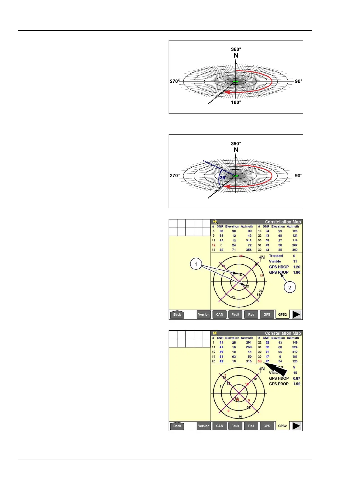
Intheillustrationshown,thevehicleislocatedatthecen-
tergreencircle.Asatellitewithanazimuthangleof207°
iscurrentlylocated207°fromnorthinaclockwisedirec-
tionrelativetothevehicle.
RCIL11DSP008ABG4
Theelevationangleofasatellite,alsocalledaltitude,is
determinedbyrstndingthecompassbearingonthe
horizonrelativetotruenorth,andthenmeasuringthean-
glebetweenthatpointandthesatelliterelativetothevehi-
cle.Elevationanglesforobjectsabovethehorizonrange
from207°(onthehorizon)upto90°(atthezenith).
RCIL11DSP009ABG5
Themorereliablesatellites(1)willalwaysbethesatellites
closesttovehicleatthecenterpointofthemap.Theyare
thesatellitesthatareathigherelevationsrelativetothe
vehicle.Thehigherelevationmeansthatthesatelliteswill
remainusefulforalongerperiodoftimebecausetheirsig-
nalislesslikelytodegradefromatmosphericconditions
andgroundclutter.
ThescreenalsoreportstheaverageHorizontalDilution
OfPrecision(HDOP)andPositionDilutionOfPrecision
(PDOP)foralltrackedsatellites(2).
RAIL12DSP1425BA6
WhenOmniSTARRTXcorrectionisinuse,GlobalOr-
bitingNavigationSatelliteSystem(GLONASS)satellites
alsoappearonthe“ConstellationMap”screen.
GLONASSsatellitesareidentiedwiththeletter“G”after
thesatellitenumber.Inthisexample,“5G”isaGLONASS
satellite.
NOTE:RTXcorrectionisonlysupportedonAFS372re-
ceivers.
RAIL12DSP1426BA7
3-96