Introduction
GRS-1 Operator’s Manual
1-2
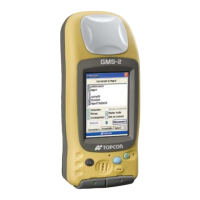
Figure 1-1. GRS-1
Principles of Operation
The GRS-1 is a fully integrated hand-held controller and GPS+
GLONASS L1, L2 receiver. An integrated electronic compass and
digital camera make the GRS-1 an all-purpose, GIS field mapping
unit.
The hand-held controller component of the GRS-1 includes the
Windows® Mobile® operating system and color LCD touch screen.
Integrated Bluetooth® and Wireless LAN technology allows this
system to be a cable-free controller/receiver for maximum portability.
The casing is durable and built for rugged use. As a field controller,
the GRS-1 can run a full suite of field software for working with total
stations and RTK GPS systems.
The GPS+ receiver component of the GRS-1 can receive and
process GPS+GLONASS L1, L2 signals improving the accuracy of
your survey points and positions. The GPS+ features of the receiver
combine to provide a positioning system accurate for any survey.
Several other features, including multipath mitigation, provide under-
canopy and low signal strength reception. When power is turned on
and the receiver self-test completes, the receiver’s 72 channels
initialize and begin tracking visible satellites. Each of the receiver’s