Viewing Upcoming Elevation Changes
You can view upcoming elevation changes along your route. This can help you avoid or plan for steep uphill or
downhill grades.
1 From the map, select > Elevation.
2 Select the chart to expand it to the full screen.
The device displays your current elevation, and a chart of elevation over distance.
3 Select an option:
• Select or to change the distance range of the chart.
• Select the arrows to scroll the chart.
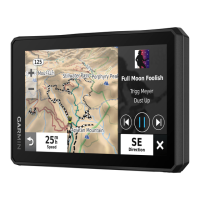
Viewing Traffic Information
Before you can view up-to-date traffic information, you must pair and connect your device to the Tread app on
your phone (Pairing with Your Smartphone, page48).
NOTICE
Garmin is not responsible for the accuracy or timeliness of the traffic information.
1 From the map, select > Traffic.
2 Touch the Traffic panel to view the traffic incidents on the map.
Viewing Weather Information
Before you can view up-to-date weather information, you must pair and connect your device to the Tread app on
your phone (Pairing with Your Smartphone, page48).
NOTICE
Garmin is not responsible for the accuracy or timeliness of the weather information.
1 Select > Weather.
The device shows the current weather conditions and a forecast for the next several days.
2 Select an option:
• Select a day to view a detailed forecast.
• Select Radar to view the weather radar map.
• Select Conditions to view a road conditions map.
• Select Alerts to view a severe weather alert map.
• Select to view the weather forecast for a different city.
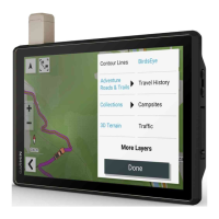
Viewing the Map Key
Elements on each map layer are color-coded to represent different information. You can view the map key to
see what each color represents.
Select > .
Viewing Trip Data
The trip data tool displays your speed and provides statistics about your trip.
From the map, select Speed.
Viewing Trip Data from the Map
Before you can view trip data on the map, you must add the tool to the map tools menu.
From the map, select > Trip Data.
26 Using the Map