Customizing the Trip Data Fields
1 From the map, select > Trip Data.
2 Select a trip data field.
3 Select an option.
The new trip data field appears in the trip data map tool.
Resetting Trip Information
1 From the map, select Speed.
2 Select > Reset Field(s).
3 Select an option:
• When not navigating a route, select Select All to reset every data field except the speedometer, on the first
page.
• Select Reset Overall Data to reset Trip A and total data.
• Select Reset Trip B to reset the odometer.
• Select Reset Max. Speed to reset the maximum speed.
• Select Reset Max. Elevation to reset the maximum elevation.
Viewing a Map Tool
1 From the map, select .
2 Select a map tool to open it.
TIP: With some map tools, you can touch the map tools to expand it or show more detailed information.
3 When you are done using the map tool, select .
Customizing the Map
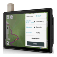
Customizing the Map Layers
1 From the map, select > Layers.
2 Under Map Type, select a map type.
With some map types, you can select > Hybrid Map to combine two map types.
NOTE: The Satellite Imagery map shows satellite images only for areas where you have downloaded satellite
imagery (Downloading Outdoor Maps+ Content, page28).
3 Under Map Details, select the types of information to display over the map.
NOTE: Some layers are incompatible with each other and cannot be enabled at the same time. Enabling a
layer automatically disables any incompatible layers.
NOTE: Some map layers require an Outdoor Maps+ subscription.
Using the Map 27