y
_._
...
~~
Keypad:
Enter
the street
name.
You
do
not
need
to
add
direction
prefixes
(N,
E,
W,
S,
etc.) but
you
can
if
desi
red
to
limit the
number
of
streets displayed.
700·799
Please refer to the User Manual
on
he
CD-ROM for more information
on
using
the keypad and the QuickSpell®
feature of the Magellan
ae
tro.
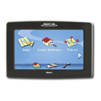
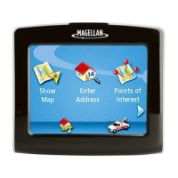
The
Map
screen
will
be
displayed
and
you
wi
II
be
provided routi
ng
instructions.
AbbeyCt
n
Diego,
(A
n
Dil'go,
TX
n
Dimas,
(A
AbileneRd
S. Acaclil
St
N
AcaciaSt
N. Aguirre Ave
Sele<t
City
Name
Select
Street
Name
Routing
to
4
bars
green: Strong signal
Blank:
No
satellite signals.
Unable to compute position.
Finding satellites
Tracking 6
Leave
the
garage
or
parking structure
so
the
GPS
receiver
has
a
clear
view
of the
sky.
Move
away
from
large
structures
or
overhanging trees that
may
interfere with satell ite reception.
You
may
need
to
relocate the Magellan Maestro
in
your
vehicle
to
have
a better
view
of
the
sky.
For
detailed
GPS
information,
access
the
MFG
GPS
Status
screen.
Main
Menu>
User
Options>
GPS
Options>
GPS
Status
Tips
on
improving satellite signal strength
This receiver
may
not
be
able
to
get satellite signals while indoors. If
you
are
not getting strong satellite signals,
go
outside
and
follow the tips
provided
above.
Tap
on
the satellite status
GPS
Status
icon to get a visual
--~--".-
...
.,..-------~,
representation of the
satellites and signal strength.
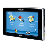
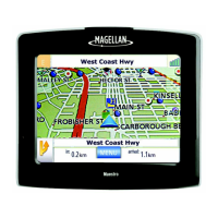
K
I
J
.1
mi
J-
kewood [
.Barrington
Point
Rd
N
Ela
Rd
etails
haron Dr
Whitney
Dr
I"
valley
Kd
B
--------'.
A
~-----~-·-----I
kook
Rd
DOOr
L
c
D
Zoom
out.
Direction
of
travel.
Tap
to
display Locate screen.
Present
speed.
While routing, displays distance
of
route.
Current street
name.
Map
scale.
Turn
instructions for
next
manuever.
Tap
to display maneuver
list. (available only
when
routing)
Current time. While routing, displays distance to next
maneuver
and
if tapped, repeats last
manuever.
Access
Main
Menu.
Street
name
for
next
maneuver.
(available only
when
routing)
J
Vol
u
me
control
K
Zoom
in.
L Satellite Status.
Tap
to
display
add
itionaI satellite
information.
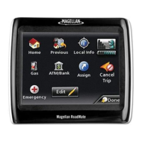
F
A
B
C
o
E
Left turn
in
1.1 miles
on
N.
Ela
Rd.
Will arrive
at
final
destination
in
4.1 miles.
G
H
Reading the
information bar
Map
AAA Roadside
Assistance details
Detour
on
existing
route
AAA Roadside
Assistance detail
Create a route with
multiple
destinations
Search for POls
on
approaching off-ramps
Select user options
14
Create a route to
an
address
Create a route to a
point of interest
Route to home
address
Return to Map
Screen
Search for POls
on
approaching off-
ramps
Cancel existing
route
ain
Menu
Main Menu (while routing)