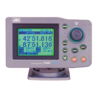
GPS Navigator J-NAV500
29
Waypoint number
Displays the number of currently selected waypoint for destination.
Example: WPT 001 WPT: waypoint
001: waypoint number
When waypoints are registered through events, a “D” or “G” is appended to the waypoint number to
indicate the position fixing of GPS or DGPS, respectively.
Waypoint name
Displays the name registered for a waypoint.
Current position
The position is displayed in the following two ways.
1. Latitude and longitude (default)
2. Loran C time differences
The time difference display is designed for users of the Loran C navigation system.
(See Section 4.13, Position Display Mode/Position Correction/Geodetic System Correction/Magnetic
Compass Correction.)
Navigation information
Displays one of the following data
1. BRG/DTG/COG/SOG (default)
2. BRG/DTG/XTE/TTG
3. CMG/VTD/COG/SOG
• BRG :Bearing to destination (unit: )
• DTG :Distance to go to destination
Unit : nautical miles (nm) (default), sm, km
• COG :course over ground (unit: )
• SOG :average speed of ship (speed over ground )
Unit : kt (knots) (default) (when the distance unit is nm), mh (when the distance
unit is sm), kh (km/hour) (when the distance unit is km)
• XTE :Cross track error. Deviation from course and direction to steer (unit: 0.01 nauti-
cal miles)
Steering required to return to the planned course is indicated by L (left) and R
(right).
• TTG :Time to go until arrival at destination (unit: hour, minute)
• CMG :Bearing (unit: ¡) to the current position as viewed from the origin
• VTD :Velocity toward destination
Unit : kt (knots) (default) (when the distance unit is nm), mh (when the distance
unit is sm), kh (km/hour) (when the distance unit is km)
(See Section 4.14, “Setting Navigation Display Modes and Units.”)
4
5
6
7
 Loading...

