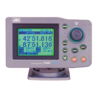
GPS Navigator J-NAV500
69
8. Specifications
Display
LCD Blue (neutral mode) STN type
Dot Materix: 128 x 100 dots
Size: 79 mm W x 61 mm H
LCD contrast adjustment Automatic adjustment by using temperature sensor and manual
adjust
Backlighting EL panel for LCD, LED for key switches
Brightness adjustment 2 step keyboard setting, high/low
Key switches 9 including 1 rotary encoder
Waypoints Max. 499
Entered as latitude/longitude, time difference or bearing/dis-
tance data
Route plans 20 plans, 199 waypoints max
Event Marks Max. 499 including waypoint memory
ShipÕs Track Max. 499 point memory
Position correction Automatic (46 geodetic systems registered)/manual
Alarms Waypoint arrival, anchor, off-course, No fix, non-connected
state, HDOP
Magnetic compass correction Automatic or manual correction
Unit Distance/speed: NM/KTS, SM/MPH, KM/PH (selectable)
Current position: 0.001Õ min
Plot function Scale: 0.125 nm to 100 nm
Track interval: 0.5, 1, 3, 5, 10 min, 0.2, 0.5 nm, OFF
GPS function Averaging: 1 to 99 sec settable (default value: 10 sec)
position fix mode: 2D/auto
Special functions •MOB function
• Simulator function (indicated as SIM)
•Loran C time difference
• 7 languages (English, German, Norwegian, French,
Spanish, Japanese, Italian)
•DGPS alarm
• Upload/download function of waypoint/route data
Data output • Output level: RS-422, TTL selectable
• NMEA0183 (version 1.5/2.1 selectable)
• Output sentences: GLL, VTG, APB, BWC, GGA, RMC, RMB
 Loading...

