GPS Navigator J-NAV500
10
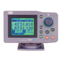
1. Overview
1.1 Functions
Attaching an optional GPS/DGPS receiver (GPS 100 or DGPS 200) makes it possible to turn the GPS
Navigator J-NAV500 into a GPS/DGPS navigational system. This navigational system uses GPS satel-
lites to calculate accurate positions anywhere in the world and under any weather conditions 24 hours
a day. This navigator displays navigational paths to entered waypoints using position data. There are
the following four navigation displays:
• POSITION Displays the latitude and longitude of the current position. It also dis-
plays the bearing and distance to a waypoint, course, speed, etc. and
the Loran C time difference.
• NAVIGATION Displays the bearing and distance to a waypoint, deviation and correct
steering direction to the route, and time to arrival to a destination.
Selections can be made to display the desired information.
• CDI Displays a graphic representation of course deviation. It also displays
correct steering direction, course and speed.
• PLOT Displays a graphic representation of the route line, the tracked line and
waypoints. Waypoints are indicated by symbols or alphabetic charac-
ters.
There is also a [STATUS] display showing status information such as satellite number, beacon fre-
quency and receiving level.
A total of 499 waypoints and 20 route plans can be entered in the navigator. A single press of the
key can turn any current location into a waypoint. Someone should fall overboard, press the
key for an instant graphic representation of that position and the route to return to this position.
 Loading...

