11
Internal data logging enables the data to be reprocessed post-mission. Data can be
collected in the unit, downloaded using “ftp”, processed on a PC and viewed using the
customer’s software.
Easy operation
There is minimal configuration required to use the system. The configuration can be
saved to the RT so it can operate autonomously without user intervention. A lot of work
has been put into the initialisation of the inertial algorithms so the RT can reliably start
to navigate in the vast majority of situations.
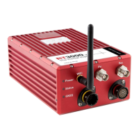
The single unit contains inertial sensors, GNSS receiver, data storage and CPU. One or
two antennas need to be mounted outside the vehicle where they have a clear view of the
sky. A 10–25 V dc power supply can be obtained from most vehicles. A laptop computer
allows real-time viewing of the results.
Self-correcting
Unlike conventional inertial navigation systems, the RT uses GNSS to correct all its
measurements. GNSS makes measurements of position, velocity and (for dual antenna
systems) heading. Using these measurements, the RT is able to keep other quantities,
such as roll and pitch accurate. Tight coupling of the GNSS and inertial measurements
means the raw GNSS data can also be used. There is no drift from the RT in any of the
measurements while GNSS is present.
Interchangeable
All RT products have identical output capabilities and are interchangeable. The serial
port, Ethernet and CAN bus are the same on all the systems including the data formats.
The connectors on the RT2000 products are different but can usually be interfaced.
Advanced processing
In poor GNSS environments, drift times can be halved by using the combined results of
processing forwards and backwards in time. Our proprietary gx/ix processing engine can
further improve performance with single satellite aiding algorithms and tight coupling of
the inertial and GNSS measurements, meaning position updates even with fewer than
four satellites in view