Page 41
Height of waypoint as to be included in its name:
o aaaNNN visible in the bottom of waypoint page.
o aaa = 3 alphanumeric character for waypoint name.
o NNN = height of waypoint over sea level, in tens of meters , N.B. if there is no value setted, navigation
will use height value field.
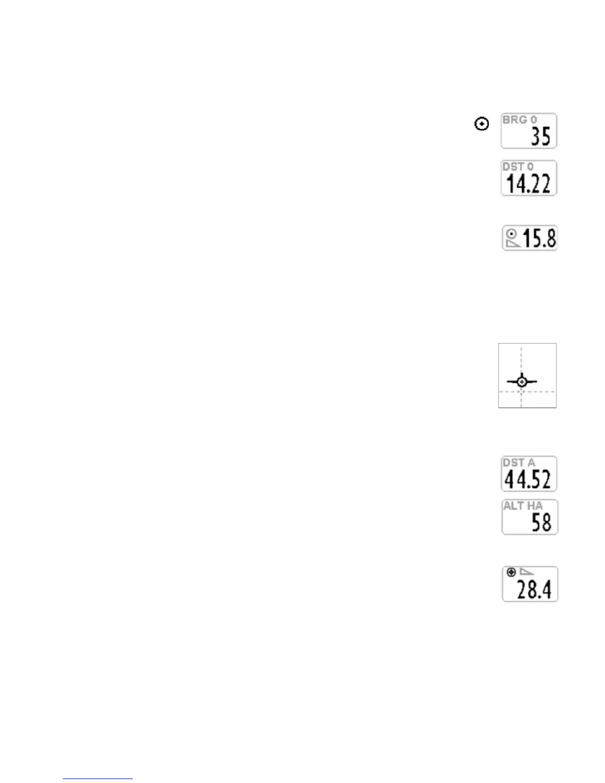
BRG 0 (B0) : shows direction to nearest point of current waypoint cylinder. Also shown with
icon on compass
DST 0 (D0) : shows distance to nearest point of current waypoint cylinder
10.4.2 NEEDED GLIDE RATIO TO CURRENT WAYPOINT
It is the estimated needed glide ratio to reach the current Waypoint's cylinder along the
optimized route
10.4.3 ARRIVAL TIME, TIME TO CURRENT WAYPOINT
Shows estimated arrival time " TIM1 (T1)" and how much time is missing to estimated arrival time " ETIM1 (E1)"
to get to current cylinder waypoint along optimized route.
10.4.4 HSI GRAPHIC NAVIGATION TO CURRENT WAYPOINT
HSI is a graphical navigation tool made by two dashed lines that intersect each other indicating
the current WPT and its real height. Flying towards the center of the WPT cylinder, the airplane
icon moves right or left of the dashed vertical line in case of wrong route and up or down the
dashed horizontal line telling us the arrival height with the current gliding ratio.
10.4.5 DISTANCE AND HEIGHT over THE GOAL
DST A (DA) : Shows distance to arrival Waypoint (goal) along optimized route
ALT HA (HA) : Shows estimated height to arrival Waypoint (goal) along optimized route.
This height is calculated as follows: Alti A1, distance to arrival waypoint (goal) DST A, height
arrival waypoint (goal) ALT HA and average efficiency.
10.4.6 NEEDED GLIDE RATIO TO THE GOAL
It is the estimated needed glide ratio to reach the Goal 's cylinder along the optimized route.
10.4.7 ARRIVAL TIME, TIME TO THE GOAL
Shows estimated arrival time " TIM A (TA)" and how much time is missing to estimated arrival time " ETIM A (EA)"
to get to arrival cylinder waypoint along optimized route.
 Loading...