Map Screen
The Map screen displays FindPoints, WayPoints, GeoHunts and GeoTrails in their
relative geographic locations. It represents a default map dimension of 100 yards (or
meters) in the east-west horizontal direction and 80 yards (or meters) in the north-
south vertical direction. Three zoom levels are available for viewing the map screen:
• 10 x 10 yards/meters per cell
• 20 x 20 yards/meters per cell (default)
• 100 x 100 yards/meters per cell
The map displays north-south and east-west grid lines, centered on your current
location. The distance between the grid lines will depend on your current zoom
level (page 15). The upper horizontal edge of the screen display will represent
north irrespective of the detector orientation.
At the top of the Map screen is the Status Bar, which displays information about the
current detector settings (page 5).
The Map screen can be displayed at any time by pressing the Map button.
GPS
The location and navigational elements of the Map screen work in conjunction with
the Global Positioning System (GPS). By default the GPS receiver is turned o and
must be turned on through the Options menu (page 48). Once GPS is turned on
a ashing GPS icon will appear on the Status Bar. When an absolute position x has
been established (which may take several minutes), the GPS icon on the Status Bar
will stop ashing and remain static.
On entering the Map screen a marker will be displayed at the centre of the screen
to represent your initial start location. If there is a valid GPS position x, movement
will be displayed on the map as a series of dots that form a GeoTrail.
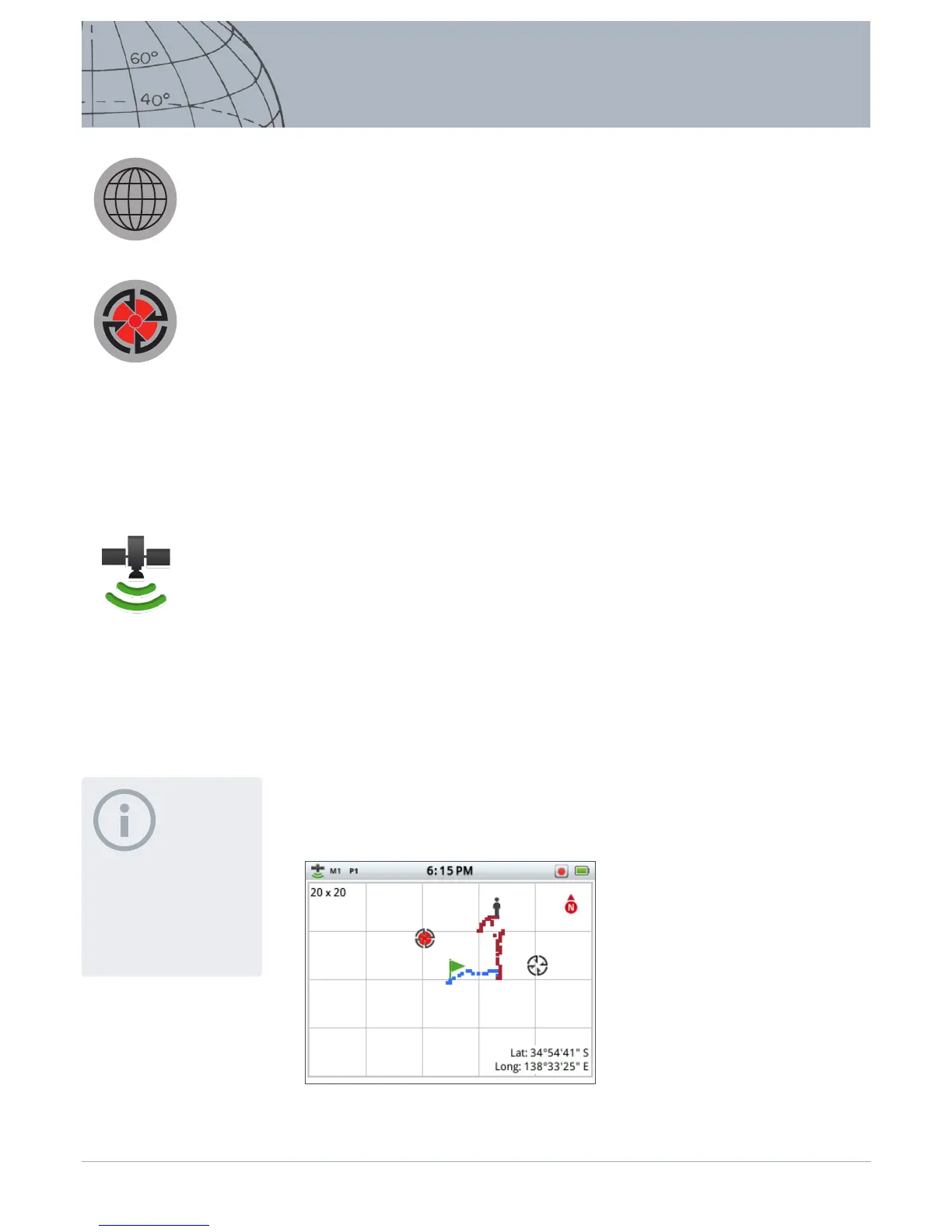
Map Screen Content
The content of the Map Screen will vary according to its current state and your user
preferences. The Map screen can display the following elements:
• Zoom Level
• Start Trail
• Current Position
• FindPoints and WayPoints
• GeoTrail
• GeoHunt
• North Marker
• Latitude and Longitude
Figure 14 – Map screen showing all content elements
NOTE
If there is no WayPoint, FindPoint
or GeoHunt near the current
location, the Map screen may be
blank.
Map
Store
The map screen is used in
conjunction with the Map and
Store control buttons.
GPS Status Bar Icon
 Loading...