Cruise / Enroute 5-19
• Airports nearest to present position
• Airports nearest to destination
• Nearest VORs
• Nearest NDBs
• Nearest Intersections
• Nearest ARTCCs
• Nearest FSS
You may also manually select either the “Nearest” or “Map
Nearest” tabs of the FMS page and cycle through the list from
those tab/pages.
If GPS position is not available, an error message is displayed.
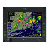
DATALINK WEATHER OPERATIONS
BROADCAST DATALINK
The Broadcast link is a transmission to your aircraft via the
WSI/Sirius system to the integrated Avidyne MLB700. Broadcast
Datalink requires a fixed monthly subscription and the receiver
receives WSI-provided weather data continuously. You can
control display of the received data on the various moving map
pages.
WSI provides US, Canadian, Mexican, and Caribbean METARS
and TAFs and US RADAR. Product availability depends on the
level of WSI subscription chosen.
Note: Avidyne does not control, review, or edit the information
made available by WSI, and is therefore not responsible for the
accuracy of that information.
The coverage area for Datalink weather is defined by diagonal
lines. If, however, Datalink radar is unavailable in a particular
area for any reason, hatched lines appear in that area. In the
mountains and off the coast, hatched lines may represent no
coverage below 10,000 feet. If there are radar returns in that
region above 10,000 feet, the returns will be displayed as “islands
of precipitation” surrounded by the hatched lines.