Do you have a question about the dji M30 T and is the answer not in the manual?
Guidelines for safe flight operations concerning environment, weather, and wireless communication.
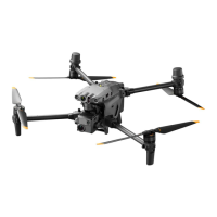
Introduction to the aircraft's vision and infrared sensing systems for obstacle detection and positioning.
Details on the detection range and blind spots of the vision and infrared sensing systems.
Steps for vision system calibration and its role in indoor navigation and positioning accuracy.
Guidance on obstacle sensing, its limitations, and potential system warnings.
How the Home Point is recorded and overview of Smart RTH and Low Battery RTH.
Details on low battery warnings, auto-landing procedures, and user actions.
Automatic RTH activation and the step-by-step sequence for return-to-home.
Important safety considerations for RTH, including obstacle sensing during the process.
How landing protection works during auto-landing and its operational circumstances.
Introduction to DJI's GEO system, GEO Zones, and flight restrictions.
Details on Authorization, Warning, and Altitude Zones, including restrictions and procedures.
Methods for unlocking GEO Zones, including Self-Unlocking and Custom Unlocking.
Step-by-step instructions for calibrating the aircraft's compass, including precautions.
Procedure for emergency landing when a motor fails, including user controls and safety advice.
Explanation of DJI AirSense technology for detecting manned aircraft and collision avoidance.
A comprehensive checklist of pre-flight checks to ensure safe operation and readiness.
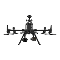
Overview of the RTK module, enabling/disabling it, and setup with D-RTK 2.
How to use Network RTK for positioning by connecting to an approved RTK server.
Steps to connect to a Custom Network RTK server for differential data.
Instructions for charging the remote controller and checking its battery status.
Methods for linking the remote controller to the aircraft using buttons or DJI Pilot 2.
Overview of the three pre-programmed control stick modes (Mode 1, 2, 3) for aircraft operation.
Detailed explanation of left and right stick functions in Mode 2 for aircraft control.
Description of Normal, Sport, and Function modes, including their capabilities.
Cautions for using Attitude mode, its limitations, and potential flight hazards.
Introduction to Advanced Dual Operator mode allowing two pilots to control the aircraft.
Detailed guide on using Advanced Dual Operator mode, control transfer, and pilot roles.
Safety warnings and instructions for charging batteries and the remote controller.
Details on Album, Academy, and Health Management System sections.
View aircraft health, flight mode, battery levels, and set RTH altitude and other parameters.
Explanation of PFD elements like speed wheel, artificial horizon, and obstacle indicators.
Details on horizontal obstacle sensing areas, blind spots, and warning indications.
Using Smart Track to identify, lock, and track targets like people or vehicles.
How to control aircraft and gimbal during target tracking using remote controller sticks and dials.
Overview of Mission Flight types: Waypoint, Mapping, Oblique, Linear, and Live Mission Recording.
Creating flight routes by adding and configuring waypoints on the map.
Recording aircraft position and photos to create waypoints for missions.
| Operating Temperature Range | -20° to 50° C (-4° to 122° F) |
|---|---|
| Max Flight Time | 41 minutes |
| Ingress Protection | IP55 |
| Gimbal | 3-axis (tilt, roll, pan) |
| Mechanical Range Tilt | -135° to +45° |
| Mechanical Range Roll | -45° to +45° |
| Controllable Range Tilt | -90° to +30° |
| Thermal Camera Resolution | 640×512 |
| Thermal Camera Frame Rate | 30 Hz |
| Thermal Camera Pixel Pitch | 12 μm |
| Laser Rangefinder Wavelength | 905 nm |
| Laser Rangefinder Max. Measurement Range | 1200 m |
| Remote Controller | DJI RC Plus |
| Charging Temperature | 5° to 40° C (41° to 104° F) |
| Max Takeoff Weight | 4200 g |
| Max Ascent Speed | 6 m/s |
| Max Descent Speed | 5 m/s |
| Max Horizontal Speed | 23 m/s |
| GNSS | GPS+Galileo+BeiDou+GLONASS |
| Operating Frequency | 2.4000-2.4835 GHz 5.725-5.850 GHz |
| Transmitter Power (EIRP) | 2.4 GHz: <33 dBm (FCC); <20 dBm (CE/SRRC/MIC) 5.8 GHz: <33 dBm (FCC); <14 dBm (SRRC) |
| Hovering Accuracy Range (Windless or breezy conditions) Horizontal | ±1.5 m (with GNSS) |
| Stabilization | 3-axis (tilt, roll, pan) |
| Wide Camera Lens | f/2.8 |
| Wide Camera Video Resolution | 4K@30fps, 1080p@60fps |
| Zoom Camera Sensor | 1/2" CMOS |
| Zoom Camera Zoom | 200x |
| Zoom Camera Video Resolution | 4K@30fps, 1080p@60fps |
| Thermal Camera Sensitivity (NETD) | <50 mK |
| Laser Rangefinder Accuracy | ±(0.2 m + D×0.15%) (D is the measurement distance) |
| Obstacle Sensing Type | Omnidirectional binocular vision + ToF |
| Sensing Range Backward | 0.5-20 m |
| Sensing Range Downward | 0.5-20 m |
| Video Transmission System | OcuSync Enterprise |
| Max Transmission Distance (Unobstructed, free of interference) | 15 km (FCC); 8 km (CE/SRRC/MIC) |
| Video Transmission Resolution | 1080p/30fps |
| Battery Type | LiPo |