EasyManuals Logo

Garmin G1000 Guide

Garmin G1000
724 pages
To Next Page IconTo Next Page
To Previous Page IconTo Previous Page
Page #711 background imageLoading...
Page #711 background image
190-00709-05 Rev. D
Garmin G1000 Pilot’s Guide for the Socata TBM 850/900
697
APPENDIX E
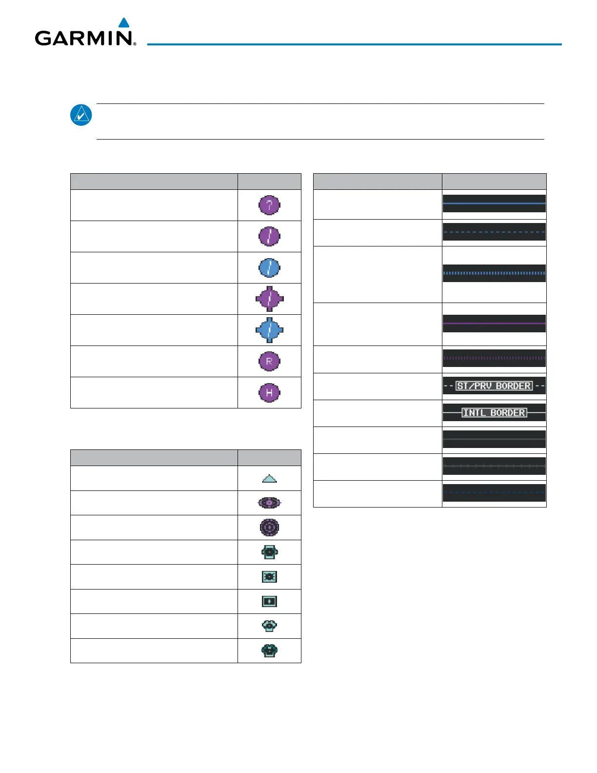
AIRPORT
Item Symbol
Unknown Airport
Non-towered, Non-serviced Airport
Towered, Non-serviced Airport
Non-towered, Serviced Airport
Towered, Serviced Airport
Restricted (Private) Airport
Heliport
NAVAIDS
Item Symbol
Intersection
LOM (compass locator at outer marker)
NDB (non-directional radio beacon)
VOR
VOR/DME
VOR/ILS
VORTAC
TACAN
LINE SYMBOLS
Item Symbol
ICAO Control Area
Class B Airspace
Mode C Tower Area
Warning Area
Alert Area
Caution Area
Danger Area
Prohibited Area
Restricted Area
Training Area
Unknown Area
Class C
Terminal Radar Service Area
Mode C Area
Military Operations Area (MOA)
State or Province Border
International Border
Road
Railroad
Latitude/Longitude
MAP SYMBOLS
NOTE
: Refer to the Flight Management Section for the topography legend and the Hazard Avoidance
Section for XM WX Satellite Weather Product legends.

Table of Contents

Other manuals for Garmin G1000

Questions and Answers:

Question and Answer IconNeed help?

Do you have a question about the Garmin G1000 and is the answer not in the manual?

Garmin G1000 Specifications

General IconGeneral
Display TypeLCD
Primary Flight Display (PFD)Yes
Multi-Function Display (MFD)Yes
Terrain AwarenessYes
Autopilot IntegrationYes
Integrated Flight Deck SystemYes
Weather RadarOptional
Traffic Advisory System (TAS)Optional
Terrain Awareness and Warning System (TAWS)Yes
Resolution1024 x 768 pixels
Weather DataYes
NavigationYes
AHRSYes
Air Data Computer (ADC)Yes
InterfacesARINC 429, RS-232
CertificationTSO certified
Traffic InformationOptional (requires ADS-B or TCAS)

Related product manuals