Section 4 Operation
55
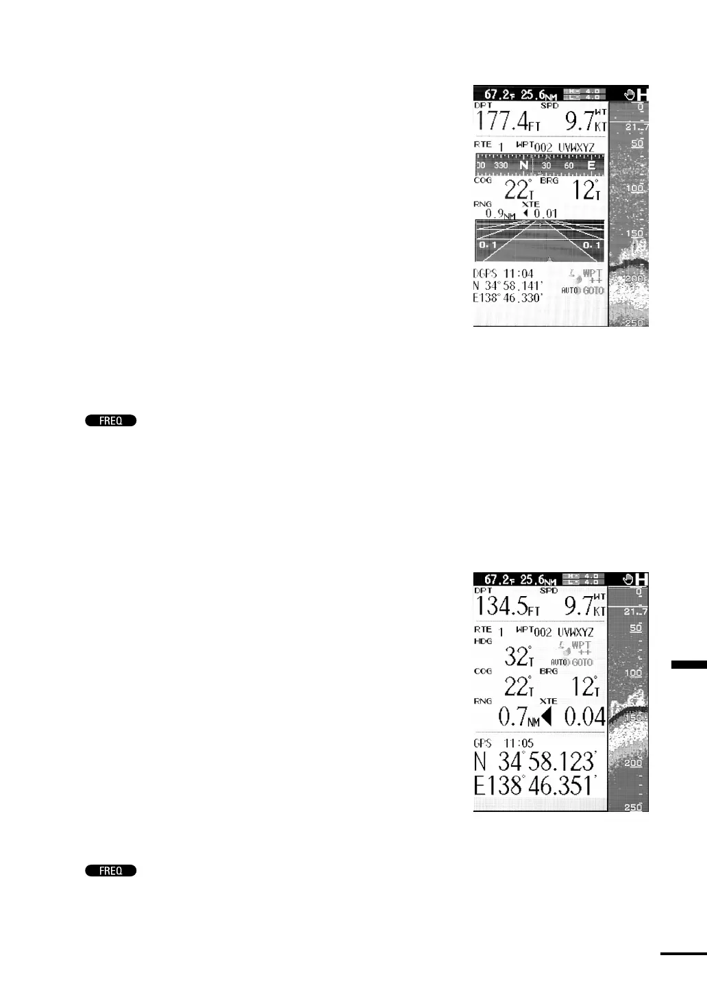
Navigation Mode type1 (Graphic Display)
•Select STD/NAV1 to divide the screen vertically in two in the ratio of
6:1. It shows the high or low frequency standard display on the right
side of the screen and the NAVIGATION type1 window on the left
side of the screen.
The NAVIGATION type1 window includes the numerical data,
compass window and highway window. Three types of information
are displayed at the same time. The numerical data includes such
information as water depth, vessel speed, course, and your vessel’s
position. The compass window indicates the relation between your
vessel’s course and the destination. The highway window indicates
your vessel’s position relative to the course. The water temperature and
Trip Log are also displayed at the top of the screen. To display the
information mentioned above, however, it is necessary to connect a
GPS/DGPS sensor (optional) and activate FOLLOW ROUTE, or to
receive the NMEA0183 formatted navigation information sentences
from external navigation aids and switch the NAVIGATION function
from internal monitor to external monitor. Refer to “Monitor Mode”
p.70 for information about how to switch to the external monitor.
Push
to toggle between the high and low frequencies.
Note:
The Trip Log is calculated from the indicated vessel speed. For this
reason, when through water is selected, a value different from the true
distance traveled may be displayed due to the influence of current and
other factors.
Navigation Mode type2 (Numeric Display)
•Select STD/NAV2 to divide the screen vertically in two in the ratio of
6:1. It shows the high or low frequency standard display on the right
side of the screen and the NAVIGATION type2 window on the left
side of the screen.
The NAVIGATION type2 window includes the numerical data of
various navigation information such as water depth, vessel speed,
course, heading direction, waypoint direction, distance between your
vessel and the waypoint, deviation from the course, your vessel’s
position, etc. The water temperature and Trip Log are also displayed at
the top of the screen. To display the information mentioned above,
however, it is necessary to connect a GPS/DGPS sensor (optional) and
activate FOLLOW ROUTE, or to receive the NMEA0183 formatted
navigation information sentences from external navigation aids and
switch the NAVIGATION function from internal monitor to external
monitor. Refer to “Monitor Mode” p.70 for information about how
to switch to the external monitor.
Push
to toggle between the high and low frequencies.