17.3 Operating modes
Narda IDA-3106 253
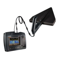
17.3.2 Direction Finding
Measurement principle Selective level measurement at a selectable frequency
from 9 kHz to 6 GHz.
Possible parameters and settings as specified under
Level Meter.
Antenna direction indication Numerical display of Azimuth, Elevation and Polarization
determined by the embedded electronic compass of the antenna
handle.
Position indication
Outdoor Instrument position displayed as latitude and longitude
(GPS WGS84) determined by the embedded GPS receiver of the
basic unit.
Optional:
Graphical indication of the current position drawn on a map.
Indoor Instrument position set manually on an editable rectangular room
layout.
Detector Peak or RMS detection
RMS averaging time: selectable, 0.12 s to 30 min
Peak hold time: 480 ms
Display modes
Manual Bearing Bar graph and numerical display of the signal level and indication
of the direction.
Horizontal Scan Polar diagram of the signal level vs. antenna orientation,
normalized to the maximum signal. Automatic direction finding and
indication.
Map Graphical indication of the triangulation results for all
measurement positions. Accepts measurements being performed
by Manual Bearing or Horizontal Scan. Display of the estimated
emitter coordinates, optional drawn on a map (Mapping option).
Horizontal Scan
Continuous Every 120 ms the polar diagram is updated with the current signal
level and compass data. Start and Stop is initiated by key press on
the antenna handle. The duration of a scan is limited to a
maximum of 4 min. The target azimuth is calculated automatically.
Discrete For every key press on the antenna handle the polar diagram is
updated with the current signal level and compass data. At least
3 samples are required for calculating the target azimuth (up to
2000 samples are possible). Useful for longer averaging times.
Discrete with Max Hold Same as for Discrete but using the highest measured values for
direction finding, ideal for intermittent signals.