Do you have a question about the NAVIS NAVIOR-24S and is the answer not in the manual?
Overview of the starter kit and its components for evaluation.
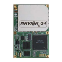
Description of the NAVIOR-24S as a GPS/GLONASS navigation sensor board.
Details on the components included in the starter kit for evaluation and troubleshooting.
Capabilities of the NAVIOR-24S receiver, including tracking, signal processing, and outputs.
Explanation of supported protocols (BINR, NMEA 0183) and DGPS configuration.
Information and part numbers for ordering the NAVIOR-24S module and starter kit.
Description of the interface unit's construction, enclosure, and connectors.
Details on power requirements, input voltage, and power supply options.
Pin designations and types for COM 1, COM 2, and COM 3 ports.
Step-by-step instructions for setting up the starter kit interface unit.
Information on software tools (BM_Ctrl, STOREGIS) provided for monitoring and integration.
Overview of the asynchronous serial port functionality as DCE.
Details on Digital IO/Power, Mating, and RF connectors used by the module.
Specifications for prime power input, including voltage and bypass capacitor recommendations.
Explanation of the direct CMOS TTL level serial I/O via UART.
Diagram illustrating serial port connections between the receiver and the customer equipment.
Description of the one microsecond wide, CMOS compatible TTL level PPS output.
Guidance on attaching the PCB to an integrator platform using a mating connector.
Information on GPS/GLONASS antennas, their frequency range, and placement requirements.
Procedure for starting the NAVIOR-24S receiver and initial signal acquisition process.
Details on supported protocols (BINR, NMEA) and communication via serial ports.
Introduction to user-friendly Windows applications for communication with the receiver.
Default protocols and port configurations (BINR, NMEA) for the receiver's I/O ports.
Explanation of temporal diagrams for 1PPS signal output in BINR and NMEA protocols.
Methods for changing port adjustments using BINR packet or NMEA messages.
Discussion on the receiver's use as a source for accurate system timing.
Overview of satellite acquisition, tracking, performance characteristics, and system architecture.
Details on GPS satellite data transmission, almanac, and ephemeris information.
Information on GLONASS satellite message structure and data flow.
Describes cold-start and warm-start procedures for acquiring satellite signals and achieving fixes.
Explanation of default elevation and RMS masks used for satellite screening.
Details on navigation, fixed position, and averaging modes for position fixing.
Configuration of DGNSS modes (On/Off) for differential correction data.
Factors degrading position accuracy and methods to minimize impacts.
Information on output protocols and the default WGS-84 coordinate system.
Key performance metrics like update rate, dynamic limits, and re-acquisition time.
How the receiver is used for accurate timing applications and its PPS signal.
Detailed description of the PPS output signal and its various output modes.
Overview of the receiver's internal components and signal processing flow.
Introduction to the BINR protocol for configuring GNSS receivers.
Details on the RS-232 serial communication line settings for BINR protocol.
Format and structure of BINR command and report packets, including DLE stuffing.
Explanation of data types and their value ranges used in BINR protocol.
Introduction to the BINR protocol for configuring GNSS receivers.
Details on the RS-232 serial communication line settings for BINR protocol.
Format and structure of BINR command and report packets, including DLE stuffing.
Explanation of data types and their value ranges used in BINR protocol.
Introduction to BM_Ctrl software for controlling NAVIS GPS/GLONASS receivers.
Specifies the PC operating system requirements for running BM_Ctrl.
Guidance on getting started with the BM_Ctrl application and its main window.
Detailed description of various functions within the BINR Tool, e.g., Receiver Test, Settings.
Standard characteristics of NMEA 0183 data transmissions.
Structure of NMEA 0183 messages, including start, ID, data fields, and checksum.
Specifies definitions for various field types used in NMEA messages.
Lists the NMEA messages supported by the NAVIOR-24S receiver.
Defines the DTM sentence for local geodetic datum and offsets.
Details the GGA message format for GNSS fix data.
Describes the GLL message format for geographic position and status.
Explanation of STOREGIS purposes, functions, and system requirements.
Instructions on starting and using the STOREGIS software.
Key features of the NAVIOR-24S GPS/GLONASS receiver.
Detailed performance specifications including accuracy, acquisition, and limits.
Technical details on connectors, protocols, electrical, environmental, and physical characteristics.
Procedure for determining a 2-D position using GPS signals.
Definition of 2 dRMS as twice the distance root mean squared error.
Procedure for determining a 3-D position using GPS signals.
Reduced-precision ephemeris parameters used for computing satellite elevation, azimuth, and Doppler.
American Standard Code for Information Interchange, a character set for computer communications.
Method of sending data where bits are sent at random times, not synchronized to a clock.
Automatically determines 2-D or 3-D position based on available GPS satellites and PDOP.
Angle of the line-of-site vector measured clockwise from true North.
| Frequency Bands | L1, L2, L5 |
|---|---|
| Receiver Type | GNSS |
| Data Output Format | NMEA-0183, RTCM 3.x, CMR, CMR+ |
| Position Accuracy (RTK) | 8 mm + 1 ppm |
| Operating Temperature | -40°C to +75°C |
| Communication Interface | USB |