190-00709-05 Rev. D
Garmin G1000 Pilot’s Guide for the Socata TBM 850/900
537
AUTOMATIC FLIGHT CONTROL SYSTEM
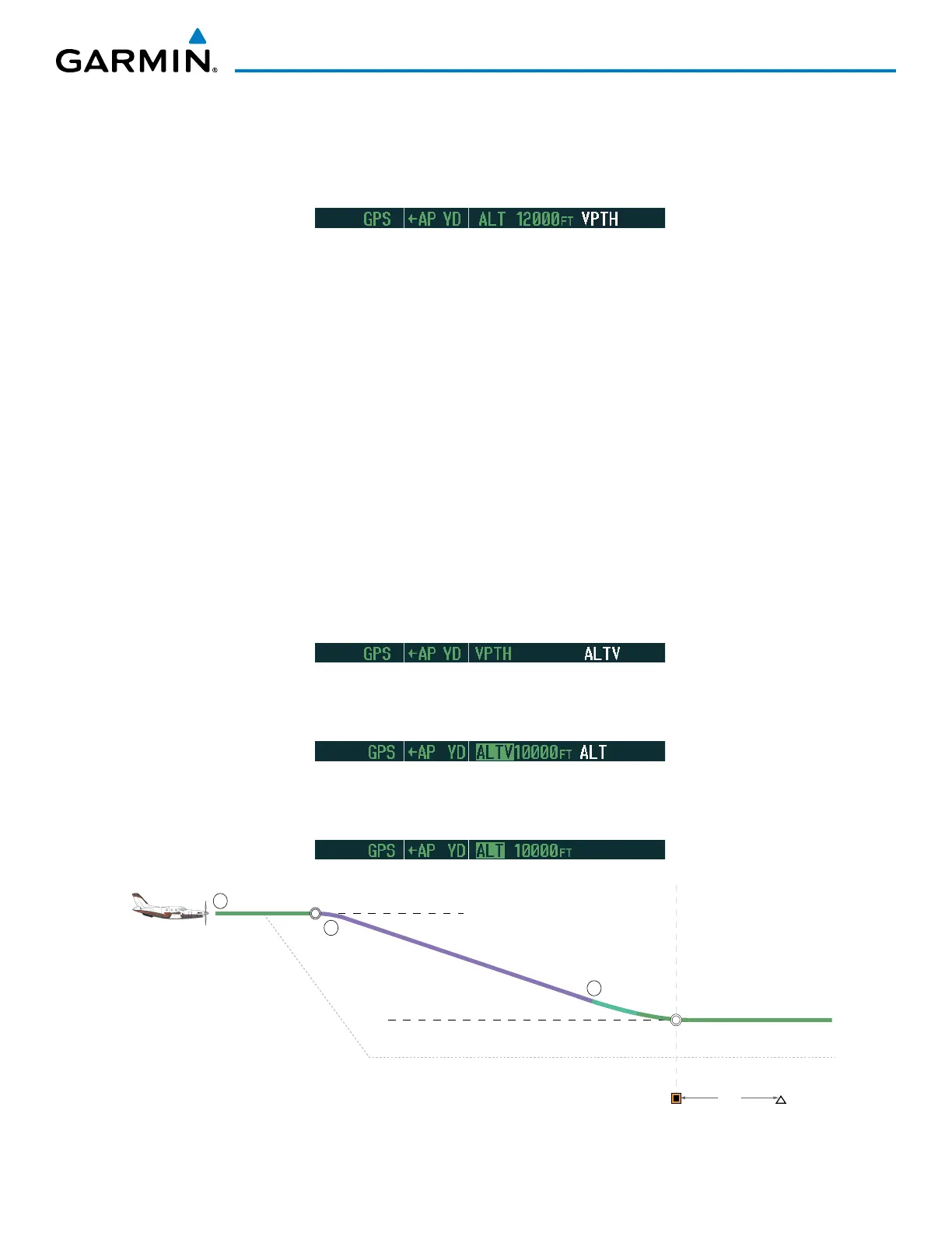
Vertical Path Tracking descent to VNV Target Altitude:
1) Select VNV flight control:
a) Press the
VNV
Key to arm Vertical Path Tracking Mode. The white annunciation ‘VPTH’ appears.
b) Using the ALT SEL Knob, set the Selected Altitude 75 feet below the flight plan’s VNV Target Altitude of 10,000
feet.
If the Selected Altitude is not at least 75 feet below the VNV Target Altitude, the flight director will capture the
Selected Altitude rather than the VNV Target Altitude once Vertical Path Tracking Mode becomes active (ALTS
will be armed rather than ALTV).
c) If Vertical Path Tracking Mode is armed more than 5 minutes prior to descent path capture, acknowledgment is
required for the flight director to transition from Altitude Hold to Vertical Path Tracking Mode. To proceed with
descent path capture if the white ‘VPTH’ annunciation begins flashing, do one of the following
• Press the VNV Key
• Turn the ALT SEL Knob to adjust the Selected Altitude
If the descent is not confirmed by the time of interception, Vertical Path Tracking Mode remains armed and the
descent is not captured.
2) When the top of descent (TOD) is reached, the flight director transitions to Vertical Path Tracking Mode and
begins the descent to the VNV Target Altitude. Intention to capture the VNV Target Altitude is indicated by the
white ‘ALTV’ annunciation.
3) As the aircraft nears the VNV Target Altitude, the flight director transitions to VNV Target Altitude Capture Mode,
indicated by the green ‘ALTV’ annunciation flashing for up to 10 seconds.
The green ‘ALT’ annunciation flashes for up to 10 seconds upon reaching 50 feet from the VNV Target Altitude;
the autopilot transitions to Altitude Hold Mode and levels the aircraft at the vertical waypoint.
Figure 7-40 VPTH Descent
3 nm
Cruise Altitude of 12,000 MSL
VNAV Target Altitude of 10,000 MSL
ALT Mode
VPTH Mode
Selected Altitude (set below VNAV Target Altitude)
1
2
3
TOD
BOD
ALT Mode
Along-track Offset, 3 nm before OPSHN

 Loading...


