- 42 -
BASIC OPERATION
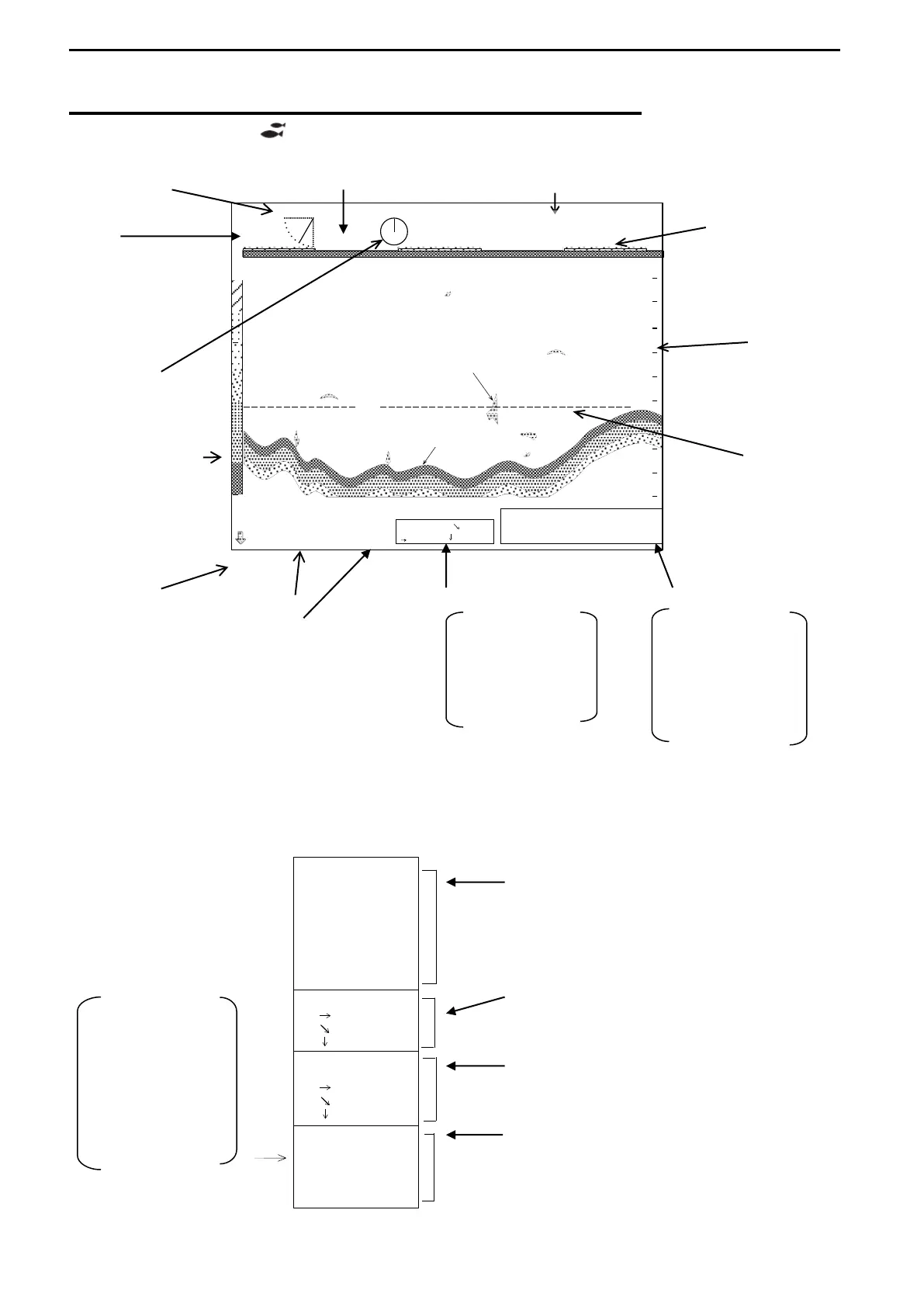
SAMPLE DISPLAY of SOUNDER MODE
Select MODE KNOB ( ) to display the SOUNDER MODE.
TILT ANGLE WATER TEMPERATURE #6
#1 TIME MARKER
#2
SEA SURFACE
SCALE
BEARING ECHO (RANGE)
INDICATOR
SEA BOTTOM
RAINBOW PATTERN RANGE
MARKER
DEPTH #4 #5
#3
INTERFERENCE
REJECTION
The above values of #1, #2, #3, #4, #5 and #6 are not displayed when the Sub-Display,
INFORMATION display is active. The depth display is available only when the tilt angle
–90°set.
0
64
96
128
T-60
゜
B 0
゜
32
105
100
160
m
34゜33.40’N
24.3 V
IR-ON
137゜03.84’E
24.7゜C
100m
86.9m
50.2m
16.0kt
SHIP’S POSITION
LATITUDE AND
LONGITUDE
SPEED
POWER SUPPLY
VOLTAGE
MARKER
HORIZONTAL
DISTANCE
SLANT
DISTANCE
DEPTH
50.2m
100m
86.9m
十 ---゜
----m
----m
----m
137゜03.84’E
34゜33.40’N
IR-O N
MARKER
CURSOR
RANGE
160m
BEARING
0゜
SECTOR
---
゜
TILT
-60゜
WATER
27.4゜C
SPEED
POWER
24.
3 V
16.0kt
When the Sub menus other than
INFORMATION selected,
They are displayed in the Sounder Mode
Display (#1, #2 and #3).
“IR-ON” is not displayed when
INTERFERENCE REJECTION OFF selected.
They are displayed as the data of the range
marker in the Sounder Mode Display (#4).
They are not displayed in the Sounder
Mode Display.
They are displayed in the lower right corner of
Sub-Display (#5). The latitude/longitude and
the speed of the ship are displayed only when
an external navigator connected.
POWER SUPPLY
VOLTAGE
WATER TEMP.
SPEED
SHIP’S POSITION IN
LATITUDE AND
LONGITUDE