AeroNav 900/880 Series Pilot’s Guide
89000039-010
Rev 1 May 2019 Map Subsystem 4-19
NOTE
Datalink Data Accuracy
BendixKing does not control, review, or edit the
information made available by the datalink products,
and is therefore not responsible for the accuracy or
timeliness of that information.
NOTE
Datalink Data Intended to Aid Decision Making
Weather Datalink information is meant to aid pilot
planning and near-term decisions focused on avoiding
areas of inclement weather that are beyond visual range
or where poor visibility precludes visual acquisition of
inclement weather. The system is not designed for use
for weather penetration and storm cell circumvention.
The system lacks sufficient resolution and updating
necessary for tactical maneuvering.
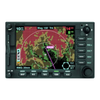
DATALINK RADAR
The Datalink radar is a composite image depicting precipitation as
seen by multiple ground-based weather radar sites. The image is
color-coded to FAA definitions to show intensity levels and