Title Customizing the Map
Identifier GUID-967C4E16-DAAA-48B9-9480-109AE1B69C8A
Language EN-US
Description
Version 1
Revision 2
Changes QA’d EN, AF, AR, BG, CS, DA, DE, EL, EN-GB, ES, ET, FI, FR, HR, HU, IT, KO, ZH-CN, ZH-TW, SL, SK, LT, LV,
NO, PL, PT, RO, RU, SV, TR
Status Released
Last Modified 05/08/2012 15:33:58
Author romine
Customizing the Map
Title Customizing the Map Layers
Identifier GUID-7F6C0A18-0F20-45F2-9A20-69B83A64A527
Language EN-US
Description
Version 5
Revision 3
Changes Updating the context statement for use in off-road
Status Released
Last Modified 29/03/2021 10:42:12
Author hizerdanielle
Customizing the Map Layers
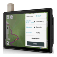
You can customize which data appear on the map, such as topographic maps and BirdsEye imagery.
1 Select > Map Display > Map Layers.
2 Select the check box next to each layer you want to show on the map.
Title Viewing the Public Lands Map Key
Identifier GUID-48178D7E-0CEB-4AA0-8091-3DC46A352925
Language EN-US
Description
Version 1
Revision 7
Changes
Status Released
Last Modified 25/11/2020 10:38:07
Author hizerdanielle
Viewing the Public Lands Map Key
Public lands are color-coded on the map to show who owns a specific plot of land. For example, you can see if a
plot of land is privately owned or if it is part of a national park. You must enable the public lands map layer to
use this feature (Customizing the Map Layers, page 49).
You can view the legend for these colors on the device.
Select > Map Display > Map Layers > > Public Lands.
Using the Map 49