Do you have a question about the 3M Dynatel 2250M and is the answer not in the manual?
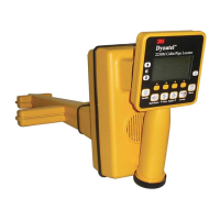
Specifies the intended use of the 3M Cable/Pipe/Fault Advanced M-Series Locator for underground utility lines.
Instructions for installing batteries in the transmitter unit, including cautionary notes.
Steps for installing batteries in the receiver unit, with cautionary notes.
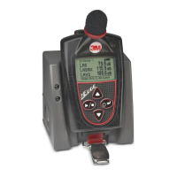
Explains the keypad and connector functions of the 3M Dynatel 2250 Transmitter.
Details the keypad and connector functions of the 3M Dynatel 2273 Transmitter.
Information on achieving maximum output levels using external power sources.
Details the use and specifications of the 3M Dynatel 2200RB rechargeable battery.
Explains how to navigate and use the Main Menu for setting up the receiver.
Details COM port settings for communication with GPS devices and PCs.
Covers receiver configuration for depth units, clock, and language settings.
Explains how to perform a self-test on the receiver and view unit information.
Describes how to access on-screen instructions and basic operating information.
Steps to select units of measure (inches, cm, feet/inches) for depth readings.
Instructions for setting the receiver's time, date, and date format.
Procedure for selecting the receiver's display language.
How to select frequencies for the receiver to detect.
Procedure for selecting frequencies detectable via the external jack.
Steps to program custom frequencies for receiver detection.
How to filter power frequency interference using user-defined frequencies.
How to choose the audio response for Directional Peak mode.
Instructions for using the direct connect method to apply a trace signal.
Steps and warnings for using the Dyna-Coupler method to apply a locating signal.
Explains the induction method for applying a signal when direct connection is not possible.
How to trace paths using passive induction without a transmitter.
Describes active induction sweeps for locating multiple cables without direct access.
How to use passive sweeps with existing signal sources.
Instructions for performing active induction sweeps with one operator.
Guide for performing active induction sweeps with two operators.
Explains the Directional Peak mode for analyzing magnetic field patterns.
Describes the Directional Null mode for locating cables/pipes.
Details the Special Peak mode for deep cables or weak signals.
Explains the Induction Peak mode for minimizing distortion from the magnetic field.
Describes the Expanded mode for pinpointing target cables/pipes.
How to initiate depth measurement and what readings represent.
How to save depth readings to memory.
How to delete all stored depth readings.
How to exit the depth measurement function.
Using active trace signals supplied by the transmitter.
Using passive power frequencies (50/60 Hz and harmonics) for tracing.
Detecting signals like CATV cables using passive frequencies.
Using signals from remote transmitters or frequency generators.
How to measure the depth of an Active Duct Probe.
Steps for setting up the transmitter for fault locating.
Steps for pinpointing the location of a buried fault using the Earth Contact Frame.
How to enable or disable specific marker types for detection.
How to set up alert mode for marker detection.
Steps for locating a single marker.
Steps for locating two markers simultaneously.
How to measure the depth of an iD Marker.
How to measure the depth of a non-iD marker.
Steps to create new templates for iD marker data.
How to select and modify existing templates.
How to alter information before writing it to an iD marker.
Accessing the historical file of information read from targeted markers.
How to view the history of data sent to markers.
How to enter the activation key to enable GPS compatibility.
How to find the unit's model, serial, software, and hardware versions.
Steps for entering the GPS activation key.
Configuring COM port settings for GPS device communication.
How to capture GPS coordinates for marker locations.
How to send iD marker data directly to GPS devices.
Using GPS to map the path of underground target facilities.
Using toning for locating aerial faults.
Steps for identifying cables using Dyna-Couplers.
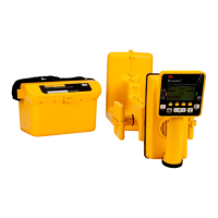
Details of the 2250M and 2273M locator models.
Lists standard packages and part numbers for transmitters and receivers.
Lists optional accessories and their part numbers.
| Brand | 3M |
|---|---|
| Model | Dynatel 2250M |
| Category | Measuring Instruments |
| Language | English |