Do you have a question about the Geoscan 201 and is the answer not in the manual?
Provides an overview of the Geoscan 201 UAV User Manual and its purpose.
Describes the Geoscan 201 aerial survey system and its various fields of application.
Lists all components included in the Geoscan 201 UAV delivery kit.
Provides instructions for UAV inspection, maintenance, and proper storage procedures.
Outlines essential operating instructions for the safe use of the UAV.
Specifies temperature limits, wind speed limits, and other operational constraints.
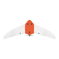
Illustrates and names the various components of the UAV.
Provides step-by-step instructions for assembling the UAV.
Lists and illustrates the individual parts of the parachute system.
Provides step-by-step instructions for correctly folding the parachute.
Provides step-by-step instructions for installing the parachute onto the UAV.
Details the standard launcher and its components.
Provides guidelines for the safe and effective use of rubber cords.
Step-by-step instructions for assembling the standard launcher.
Guides the user through the final steps before launching the UAV.
Describes the Arctic version of the launcher for cold conditions.
Provides guidelines for the safe and effective use of springs in the Arctic launcher.
Step-by-step instructions for assembling the Arctic launcher.
Guides the user through the final steps before launching the UAV with the Arctic launcher.
Details main parts and recommended settings for the Sony DSC-RX1RM2 camera.
Describes pre-configured shooting presets and how to restore them.
Procedures for formatting the SD card and resetting camera settings.
Details main parts and recommended settings for the Sony DSC-RX1 camera.
Details main parts and recommended settings for the Sony A6000 camera.
Introduces the camera, its parts, LED indications, and pre-power on checks.
Detailed steps for performing a pre-launch check of the camera system.
Instructions for calibrating the camera and DLS sensor systems.
Configuring flight projects and synchronizing photo metadata.
Provides X, Y, Z offsets for cameras in the left slot relative to GNSS.
Provides offsets for right slot cameras and RX1RM2 center position.
Lists critical safety precautions for battery and charger usage.
Details the charger's parts, control unit, and setup procedures.
Explains the battery's control button, status LEDs, and charging indicators.
Describes how to activate and monitor the battery heating feature for Arctic batteries.
Guides battery connection and provides best practices for usage and storage.
Lists minimum and recommended system specifications for the software.
Instructions for creating a new project in the Geoscan Planner software.
How to create flight routes for polygon-based and linear surveys.
Modifying flight routes, directions, start points, waiting, and landing points.
Steps to connect the radio modem and establish wireless communication.
Instructions for linking the UAV to the Geoscan Planner software.
Guides through the pre-launch preparation wizard and parameter settings.
Instructions for initiating flight mode and understanding autopilot indications.
Guides for initiating UAV landing and the overall launch checklist.
Table explaining the meaning of various autopilot LED indicators.
Step-by-step instructions for safely disassembling the UAV.
Lists detailed specifications for the UAV, cameras, battery, and modem.
Details specifications for the battery charger and UAV transport cases.