Chapter 1: Overview 1-5
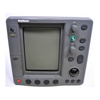
1.3 The Chartplotter
Display Features and Functions
The Raychart 425 Chartplotter includes the following :
• Detailed navigation information is displayed when a Navionics
®
Nav-Chart card is installed.
• Uses positional information from Satellite Differential GPS to dis-
play vessel’s position.
• Satellite acquisition data.
• Create, Place, Move, Edit or Erase a Waypoint.
• GoTo Waypoint, Port, Facility or Cursor.
• Display Tide Heights, Tide Currents, Sun and Moon data.
• Create, Save, Name, Edit or Follow a Route.
• Review Route and Waypoint Lists.
• Display vessel’s track on-screen.
• Convert a track to a route (SmartRoute).
• Set Up Alarms and Timers.
• Man OverBoard (MOB) to navigate back to a missing person or object.
• The display and keys can be illuminated for night-time use.
• The vessel’s position is shown as a boat symbol pointing in its current
direction.
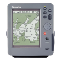
At the top of the chartplotter screen a status bar displays chart scale,
cursor position plus range and bearing or the vessel’s position, Speed
Over Ground (SOG) and Course Over Ground (COG). When in
Simulator mode, a flashing
SIM indication is displayed in inverse video in
the top left hand corner. Heading information is shown as North Up (
NU),
Head Up (
HU) or Course Up (CU) information. If in Overzoom mode, this
is indicated by
OV.
Waypoints previously placed are displayed and the current route is
shown. Data can be viewed for current route or chart object.
The chartplotter screen can also show additional information, depending
on your currently selected options, set up selections and data available
from other equipment.
An example chart display in its default configuration, with a chart card
installed, is shown in Figure 1-3.
Several functions are available to control the display as follows:
• Zoom in/out.
• Pan the Display.
• Centre the Chart around the Vessel.
Operation of these functions is described in Chapter 2.
 Loading...