Do you have a question about the Simrad NX40 and is the answer not in the manual?
Covers manual power control and automatic power management linked to the boat's ignition.
Describes the MOB function to mark position and navigate back to it.
Detailed explanation of the chart display, modes, symbols, and zoom functions.
Creating, editing, moving, and deleting waypoints via chart or waypoint windows.
Creating, editing, and deleting routes, including adding and removing legs.
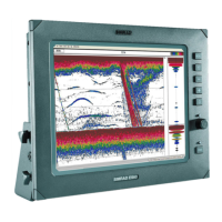
Understanding echo appearance, strength, bottom types, and fish symbols.
Utilizing 50 kHz and 200 kHz frequencies for optimal fish detection.
Techniques for finding fish and interpreting fish arches on the display.
Fine-tuning gain and threshold settings for detailed echosounder performance.
Explains how the fuel computer estimates fuel remaining, used, range, and economy.
Critical procedure for updating fuel levels to maintain accurate data.
Calibrating fuel sensors and paddlewheel speed sensors for precise readings.
Displaying and interpreting information about nearby AIS-equipped vessels.
Identifying and managing potentially dangerous vessels using CPA and TCPA data.
Understanding the radar display, its rings, lines, and symbols.
Steps to activate and configure the radar system for operation.
Optimizing radar display quality by managing clutter, gain, and interference.
Setting up guard zones and alarms to detect targets entering or exiting defined areas.
Configuring system settings: language, backlight, power, and device options.
Customizing chart display: rotation, palette, map datum, and data presentation.
Configuring echosounder settings: frequency, scroll speed, palettes, and filters.
Setting radar parameters: rotation, motion mode, interference, and guard zones.
Setting up fuel sensors, engines, tanks, and speed sources for fuel calculations.
Solutions for unit power-on issues, backlight settings, and beeping without display.
Troubleshooting for GPS fix acquisition, position accuracy, and time errors.
Solutions for inaccurate fuel readings, flow issues, and economy display errors.
Addressing erratic operation, no bottom detection, and poor fishfinding signal issues.
Solutions for radar overlay, arcs/shadows, false echoes, and clutter display issues.
| Chartplotter | Yes |
|---|---|
| Display Type | Color LCD |
| GPS | Yes |
| Sonar | Yes |
| Radar Compatible | Yes |
| AIS Compatible | Yes |
| Chart Compatibility | Navionics |