your position is our focus
4.6.10 DGPS (Differential GPS)
uttheRTCMprotocolrefertoSection 4.4.5.
e Based Augmentation Systems)
thetotalnumberof satellitesused,whichis 16forANTARIS
®
4basedproducts.Each
S , which b emeris or almanac information, can be used for navigation, just like a
n ellite.
For receiving correction ANTARIS
®
4 st SBAS satellite as its
primarysource.Itwillse sincethe dundantand/or
c istent.T rminedbytheproximityoftheGEOs,theservicesofferedby
t nfigura
e allowed/disallowed, Integrity enabled/disabled) and the
signal the
In nsare a DGPS flagis
set outpu
T rtantSBA
RIMS of aregio the
G GEO
Forinformationabo
4.6.11 SBAS (Satellit
4.6.11.1 SBAS Features
ANTARIS
®
4iscapableof receivingmultipleSBASsatellitesinparallel,evenfromdifferentSBASsystems(WAAS,
EGNOS,etc.). They can be tracked and used for navigation simultaneously. Up to threeSBAS satellites can be
searchedinparallel andeverySBASsatellitetracked
ofreceiver channelslimits
utilizes onevacantGPSreceiverchannel.Only thenumber
BAS satellite roadcasts eph
ormalGPSsat
data, the
GPS receiver automatically chooses the be
lectonlyone informationreceivedfromotherSBASGEOsisre
ouldbeincons heselectionstrategyis dete
he GEO, the co tion
of the receiver (Testmod
linkqualityto GEO.
casecorrectio vailablefrom thechosenGEOandusedinthe navigation calculation,the
inthereceiver’s tprotocolmessages.
hemostimpo
stations
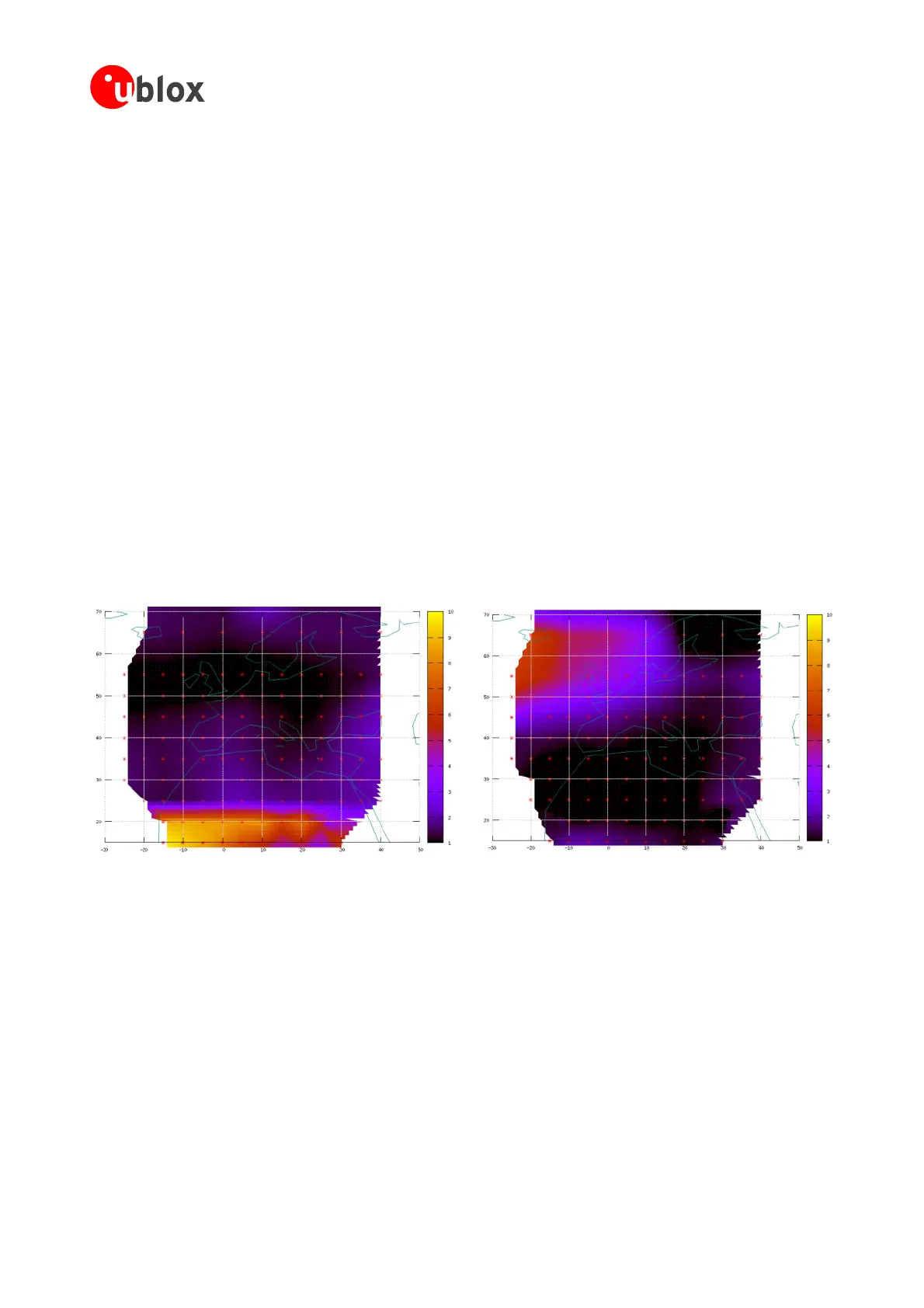
Sfeature foraccuracyimprovementis
Ionospherecorrection.Themeasureddata from
n are combinedtoaTEC (Total Electron Content)Map. This map is transferred to
PSdevicesviathe stoallowacorrectionoftheionosphereerroroneachreceivedsatellite.
Figure 84: Examples of a TEC-Map over Europe
GPSModules-SystemIntegrationManual(SIM)(incl.ReferenceDesign) ReceiverDescription
GPS.G4-MS4-05007-A1
Page 105
 Loading...