Anotherbenefit istheuseofGPSintegrityinformation.InthatwaySBASControlstationscan‘disable’usageof
GPS satellites in case of major GPS satellite problems within 6 seconds time to alarm. The ANTARIS
®
4 GPS
• RTCA/DO-229C(MOPS).Availablefrom
www.rtca.org
Technologywillonlyusesatellites,forwhichintegrityinformationisavailable,ifintegritymonitoringisenabled.
FormoreinformationonSBASandassociatedservicespleasereferto
•
gps.faa.govforinformationonWAASandtheNSTB
•
www.esa.intforinformationonEGNOSandtheESTB
•
www.essp.be for information about European Satellite Services Provider EEIG is the EGNOS operations
manager.
SBAS GEO PRN Numbers
ThePRNoftheGEO’susedforSBASareinarangefrom120to150.showstheSBASGEO’sinoperation.
GEOidentification Stationedover GPSPRN SBASProvider
INMARSATAOR-E (AtlanticOceanRegionEast) EasternAfrica 120 EGNOS
INMARSATAOR-W (AtlanticOceanRegionWest) WesternAfrica 122 WAAS
Artemis Africa(Congo) 124 EGNOS
INMARSATIOR-W(III-F5) (IndianOceanRegionWest) Africa(Congo) 126 EGNOS
MTSAT-1R Pacific 129 MSAS
INMARSATIOR (IndianOceanRegion) IndianOcean 131 EGNOS
INMARSATPOR (PacificOceanRegion) Pacific 134 WAAS
PanAmSatGalaxy15 133degreeswest 135 WAAS
MT AT-2 Pacific(notlauS nchedyet) 137 MSAS
Tele atAnik/F1Rs st 138 WAAS107degreewe
Table 2: PRN of GEO's used for SBAS
afeaturetomakeGPSmoreaccurateandreliableinurbancanyonenvironmentsandduring
e to measure its speed,
a
GPSreceiver, aturn
ratesensor(gyroscope)andaspeedindicator(odometer).Bycombiningtheinformationofallsensorsaposition
canbedeterminedevenifGPSpositioningisdegradedorimpossibleduetorestrictedskyview.Thismeansthat
aDRenabledreceivercontinuestoreportpositions,whenGPS
signalsareblocked,suchasintunnelsorinheavy
urbancanyonenvironments.
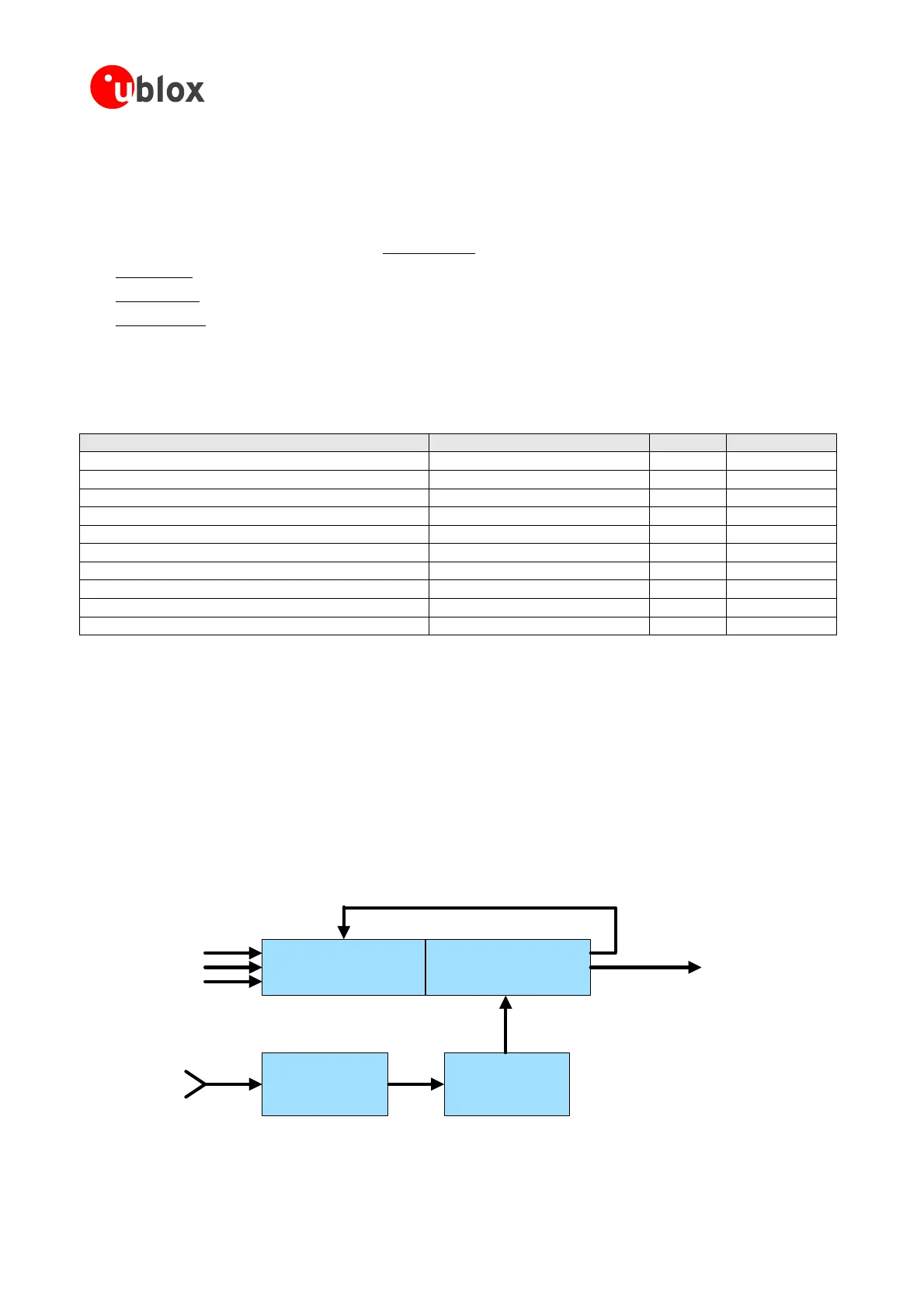
1.11 Dead Reckoning enabled GPS (DR)
Deadreckoningis
periods of GPS outage. It uses extra sensors (in addition to GPS) installed in the vehicl
headinganddirection(forward, backward).Thereforea DR enabledReceiver consistsof
GPS Kalman Filter
GPS
receiver
Dead Reckoning
Parameter
Enhanced Kalman Filter (EKF)
Position,
Speed,
Direction,
Time
Calibration
TurnRate
Speed
Forward/Backward
Signals
GPSPosition,
GPS ata
GPS
D
Figure 27: Dead Reckoning Block diagram
GPSModules-SystemIntegrationManual(SIM)(incl.ReferenceDesign) GPSFundamentals
GPS.G4-MS4-05007-A1
Page 32
 Loading...