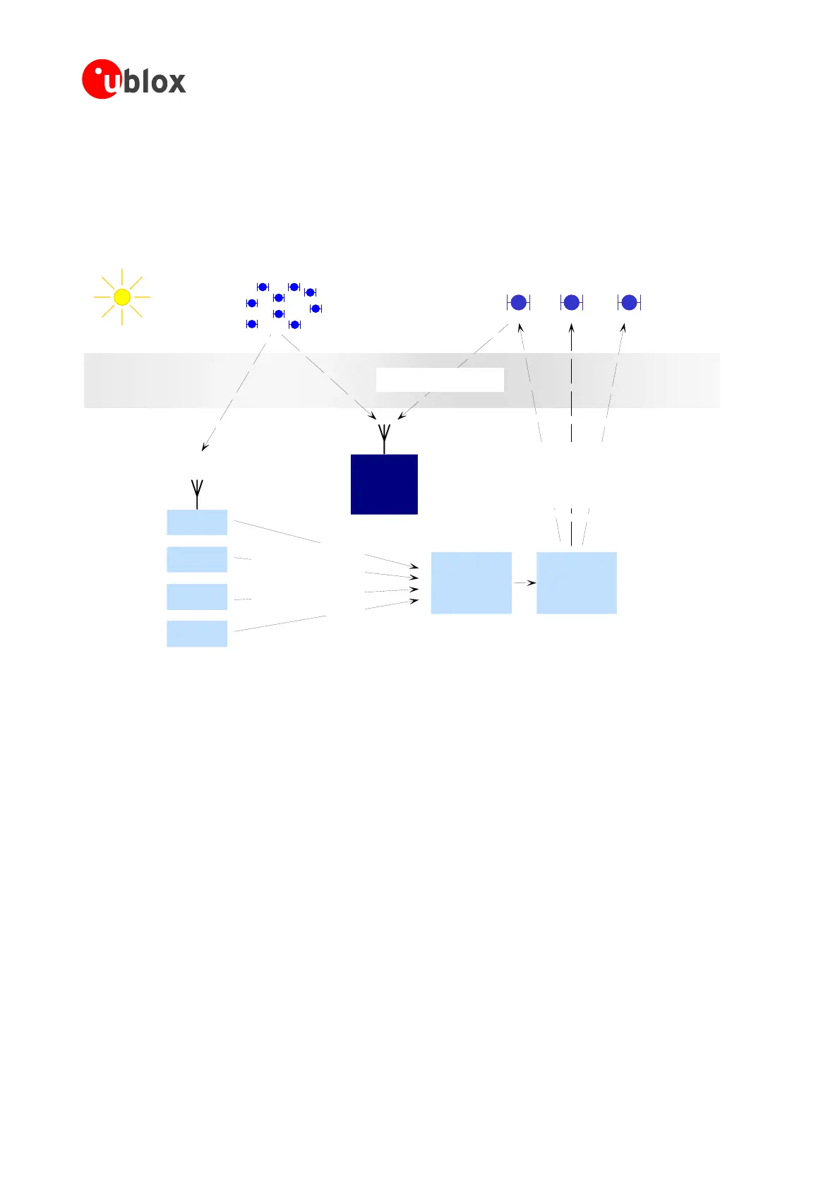
1.10 SBAS (Satellite Based Augmentation Systems)
SBAS (Satellite Based Augmentation System) is an augmentation technology for GPS, which calculates GPS
toring Stations) on the ground and uses
geostationarysatellites(GEOs)tobroadcastGPSintegrityandcorrectiondatatoGPSusers.Thecorrectiondatais
n
therefore thereis no additional receiver required to
integrity and correction data with RIMS (Ranging and Integrity Moni
tra smitted on theGPS
L1 frequency (1575.42 MHz), and
makeuseofthecorrection-andintegritydata.
Ionosphere
GPSSatellites
SB
Solaractivity
Influencessignal
propagationdelay
ASSatellites(e.g. WAAS, EGNOS), geostationaryorbit
g
(e.g.charged
particle storms)
Additional Contents:
RangingSignal(likea GPS SV)
Contents:
Ephemeriscorrec tions
Clockcorrections
Ionospherecorrections
Integrityinfo(SVuse/d einfo)
Rangingand
Integrity
Monitorin
Stations(RIMS)
atknown
locations
Uplin k
Stations
Master
Control
Centers
RIMS
RIMS
ANTAR
GPS
receiv
IS
®
er
on'tus
RIMS
RIMS
Contents:
SignalPropagationdelays
Orbitdeviations
ckerrors
hericconditions
Integrityinformation
R(OperationalReadinessReview)
inQ2/2005.FulloperationofEGNOSis planned
• MSAS(Multi-FunctionalSatelliteAugmentationSystem)forAsiaisindevelopmentstageandissendingtest
data.MSASinitialOperatingCapability(IOC)isexpectedearly2007.
OthersystemsareplannedforCanada(CSAS),India(GAGAN),Africa(EGNOS)andSouthAmerica.
SBAS
support allows the ANTARIS
®
4 Technology to take full benefit of the augmentation systems that are
available (WAAS,EGNOS),thetest beds (NSTB, ESTB)and futuresystems that areplanned (suchas MSAS) for
non-avionicsapplications.
WithSBASenabledtheuserbenefitsofadditionalsatellitesforranging(navigation).TheANTARIS
®
4Technology
usestheavailableSBASSatellitesfornavigationjustlikeGPSsatellites,iftheSBASsatellitesofferthisservice.
ToimprovepositionaccuracySBASusesdifferenttypesofcorrectiondata:
• Fast Correctionsaccountforshort-termdisturbancesinGPSsignals(duetoclockproblems,etc).
• Long-term correctionscanceleffectsduetoslow
GPSclockproblems,broadcastorbiterrorsetc.
fectsduetoIonosphereactivity
SVClo
Ionosp
Figure 26: SBAS-Principle
ThereareseveralcompatibleSBASsystemsavailableorindevelopmentallaroundtheworld:
• WAAS(WideAreaAugmentationSystem)forNorthernAmericaisinoperationsince2003.
• EGNOS(EuropeanGeostationaryNavigationOverlayService)isintestmodeESTB(EGNOSsatellitetestbed).
EGNOShaspassedtheOR
for2007.
• Ionosphere correctionscancelef
GPSModules-SystemIntegrationManual(SIM)(incl.ReferenceDesign) GPSFundamentals
GPS.G4-MS4-05007-A1
Page 31
 Loading...