INSTALLATION MANUAL
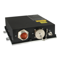
CMA-5024 GLSSU
This document includes Proprietary Information and shall not be reproduced or communicated to third party
without prior written permission by CMC Electronics Inc.
Page 2
Revision 1 Jan 19, 2009
DO-229D Options:
The GLSSU selection of options within the scope of class Beta-3 and Delta-4 is as follows:
- This equipment meets the measurement accuracy requirements for Airborne Accuracy
Designator B per DO-229D section 2.1.4.1.4.
- This equipment does not include any controls or displays (DO-229D section 2.3.1).
- This equipment can optionally host a FAS database (DO-229D section 2.3.5).
- This equipment outputs the lateral deviation with angular scaling (ILS look-alike “final approach
segment” lateral deviations per DO-229D section 2.2.4.4.2.3) on the ARINC 429 lateral
proportional deviation label. Past the end of the runway, the scaling is linear with a full scale
deflection of 0.3 nm. Refer to Appendix A section 2.C.(3) for label formatting.
- This equipment outputs the vertical deviation with angular scaling (ILS look-alike “final approach
segment” vertical deviations per DO-229D section 2.2.4.4.4) on the ARINC 429 vertical
proportional deviation label. It does not exercise the option that uses the MLVD (Minimum
Linear Vertical Deviation). Refer to Appendix A section 2.C.(3) for label formatting.
- This equipment uses a standard TSO-C190 (RTCA/DO-301) active antenna; it does not require
the use of a specific DO-301 antenna. A DO-228 antenna may be use is operation is restricted
to class 1. Refer to section II 3.A. for antenna characteristics.
- This equipment does not utilize a tight integration of GPS and inertial information to enhance
navigation or integrity performance.
- Aiding from a separate sensor is not required (e.g., inertial). The equipment computes and
outputs position (GLS busses) at a 10 Hz rate to support unaided LPV and LP navigation.
- This equipment uses barometric altitude to improve performance as per DO-229D Appendix G
when available but does not require the presence of an altitude input to meet the DO-229D
requirements.
- This equipment does not use satellites below 5 degrees to meet the DO-229D requirements as
allowed by section 2.1.1.10.
- This equipment complies with the tracking contraints per DO-229D section 2.1.4.5 (and sub-
sections) by selecting a 0.1 chip early-minus-late DLL discriminator operating in region 1 of DO-
229D Table 2-4A for GPS satellites and in region 2 of DO-229D Table 2-4C for SBAS satellites.
- This equipment does not provide missed approach capability per DO-229D section 2.3.4.2.
The GLSSU operates both within and outside the SBAS coverage area. Contact the specific service
provider for information on the coverage area. Its compliance to RTCA/DO-229D ensures
interoperability with the signals-in-space provided by the FAA Wide Area Augmentation System (WAAS)
and other international SBAS service providers (current or future) like the European Geostationary
Navigation Overlay Service (EGNOS), Japan's Multi-functional Transport Satellite (MTSAT) Satellite-
based Augmentation System (MSAS), and India’s GPS And GEO Augmented Navigation (GAGAN).
At time of publication, the following internet sites provide reference information for the current SBAS
service providers:
The document reference is online, please check the correspondence between the online documentation and the printed version.
 Loading...