9-1
Section 9 Specification
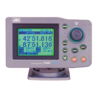
9.1 NWZ-4740 DISPLAY UNIT
9.1.1 Basic
・Display Unit :5.7 inch FSTN LCD 320×240 dots
・Backlight :LCD and Key lighting
・Dimmer Levels :Bright, Medium, dark, off
・Memories :Waypoints 10000points maximum
Event/Mark 1000points maximum (include MOB)
Track 2000points maximum
Route 100routes maximum
・Route plan :512 waypoints per one route
・Geodetic datum :Selection among 46 geodetic datum
・Magnetic Variation :Automatic or manual
・Navigation Calculation :Grate circle or Rhumb line selectable
・Alarm :Arrival, Anchor, Boundary, XTD, No position fix, Speed,
Trip, Temperature
*
, Depth
*
, HDOP
・Plot Function Scale :0.2,0.5,1,2,5,10,20,50,100,200,300NM
Interval :1~60min(1 sec) or 0.01~99.99NM(0.01NM) selectable
・Data Input/Output :RS-422 4 output ports, 1 input port, 1 LAN port
・Contact :2 output ports, 1 input port
・Selectable Unit :Distance, Speed NM,kn or km,km/h or mi,mi/h selectable
height, Depth m or ft or fm selectable
Temperature ℃ or ℉ selectable
・Loran Conversion Function:Latitude and longitude can be converted into the Loran time
difference.
・Display Language :Japanese or English
・Power Supply Voltage :DC12/24V(+30%,-10%)
・Power Consumption :less than 10W (JLR-7800)
less than 9W (JLR-7500)
less than 7W (NWZ-4740)
・Dimension :267.4(W)×162(H)×85(D)mm
・Mass :Approximately 2.3Kg
*: External sensor must be connected.
9.1.2 Environment
・Operating Temperature :-15℃~+55℃
・Storage Temperature :-25℃~+70℃
・Vibration :IEC60945 ed.4 conformant
・EMC :IEC60945 ed.4 conformant
・Waterproofing :IP44