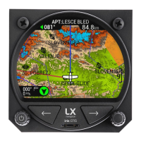
LX iris EFIS
Setup page
Document name: LX HUM
Document revision: R1
13.2.3.1 Airspace
In the ”Airspace” menu pilot can adjust colors to specific airspace. Pilot can define ”Outline”
color, ”Fill” color and ”Transparency level”.
• “Controlled Zone” Set ”Outline” and ”Fill” color
• “Prohibited” Set ”Outline” and ”Fill” color
• “Restricted” Set ”Outline” and ”Fill” color
• “Danger” Set ”Outline” and ”Fill” color
• “Terminal area” Set ”Outline” color
• “Airway” Set ”Outline” color
• “Glider” Set ”Outline” color
• “Military” Set ”Outline” color
• “Other” Set ”Outline” color
• “Class A, B” Set ”Outline” and ”Fill” color
• “Class C” Set ”Outline” color
• “Class D” Set ”Outline” color
• “Class E” Set ”Outline” color
• “Class F” Set ”Outline” color
13.2.3.2 Map
In the ”Map” menu, pilot can adjust various map related settings:
• “Orientation” Select between ”Track up” and ”North up”
• “Color Palette” Select between 14 different 3D terrain relief color palettes
• “TP/APT text size” Select between ”Small”, ”Normal” and ”Large”
• “TP/APT text color” Set the color and transparency level
• “Destination line color” Set the color and transparency level
• “Track line color” Set the color and transparency level
• “Display tail” ”On” or ”Off” option
• “Display APT name” ”On” or ”Off” option
• “Display TP name” ”On” or ”Off” option
Device manual Public 66