Software v3.0.9915
© Satmap Systems Ltd 2015
10
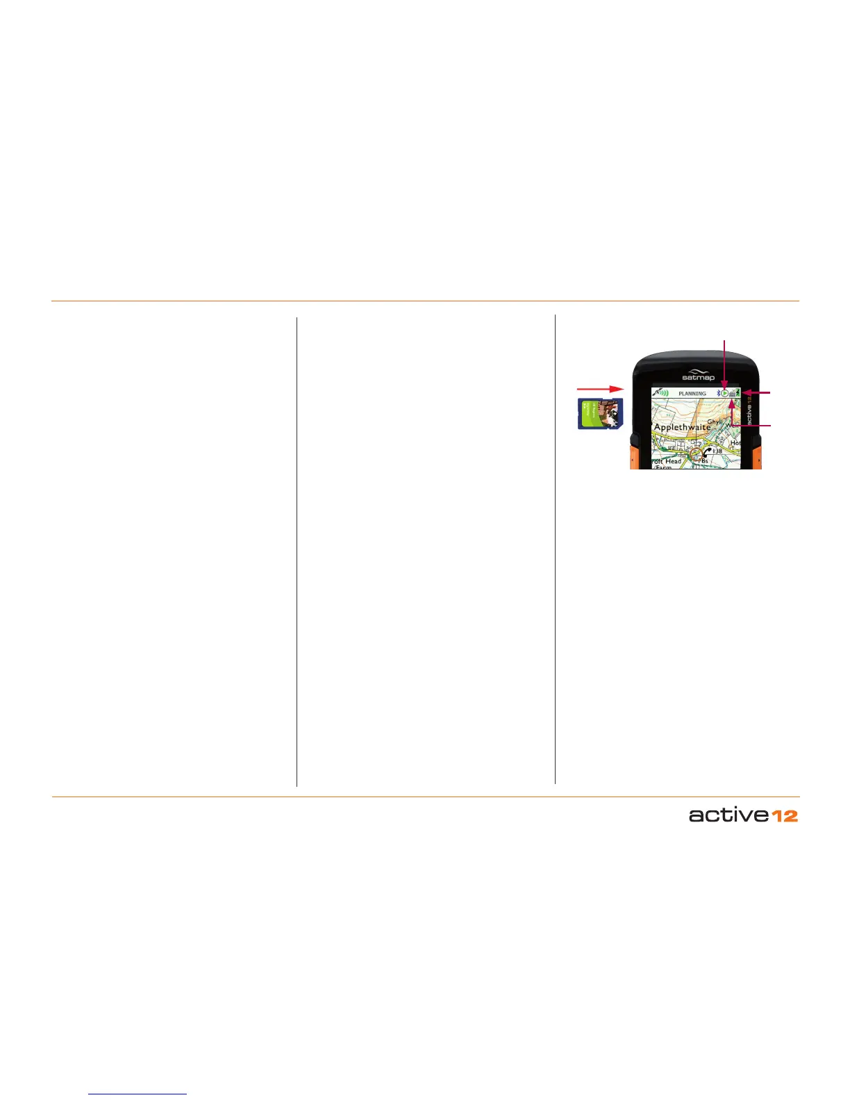
3.4 Map Card Insertion
The map card door is hinged at the bottom and
opens from the top downwards. When inserting the
card please ensure that the label is facing you with
the arrow pointing inwards.
You can make an SD card write-protected by moving
the switch on the side of the card down (saves from
accidental deletion of les).
3.5 Base Mapping
The Active 12 is supplied with a world base map
at 1:5m up to 1:200m (and in addition for UK
customers, a 1:1 m & 1:250k scale UK road map).
Once a map card has been inserted, you can zoom
through the base mapping to see more detail. If you
have a toggleable map, you can switch between
different map layers at a particular point on the
same zoom level, e.g. you can flip between the two
scales (1:50k and 1:25k) and the base map.
3.6 Battery, Strat & Stop Icons
The battery indicator is solid for new or fully charged
batteries. As the charge decreases it is broken into
four bars which then reduce. When a single bar
remains, it is coded red. After some further time
(depending on the power source and activity), an
on-screen warning alerts that the unit will power off
in 30 seconds and a countdown is shown.
If you are using the rechargeable LiPol battery
(section 20.03), the battery indicator shows a
lightning flash whilst charging. You will need to
disconnect the unit from the power supply to check
if the battery indicator is fully charged, i.e. solid.
Next to the battery indicator is the Stop/Record
icon, indicating that data logging is either paused or
recording. This can be accessed on the TRIP LOG
screen. When the unit has a lock, the record icon
has a solid green arrowhead. The record icon is
shown as ‘empty’ when there is no lock. A red pause
symbol indicates data logging is paused.
3.7 PLANNING Mode
Moving the joystick changes the screen from the
GPS MAP screen to the PLANNING screen. The
blue circle (location icon) will move away from the
middle of the screen as you control the joystick to
move the map. A visual cue that you are in planning
mode is the orange locator circle which has longer
crosshairs. In PLANNING mode you can plan
routes via the Routes Menu, study the map using
the joystick to pan across the map, and set a GoTo
point/Marker/POI.
3.8 SatSYNC
(Refer to SatSYNC User Guide)
SatSYNC is a free software available for download
from satmap.com. It allows you to connect your
Active 12 to a computer via a standard USB
connection. With this software you can upload/
download routes, Objects of Interest, and geotag
photos. These files can then be shared via e-mail
or forums (e.g. Satmap Route Share Network) or
viewed on a computer-based mapping system
(e.g. Satmap-Xpedition Online Route Planner
and Google Earth), compatible with a number of
supported formats. The Satmap-Xpediton allows
the download of pre-planned routes, the upload of
routes for editing, and the printing of a paper version
of the route to take as back-up when outdoors.
To view your trail recorded by the Active 12 on a
computer:
1.
You will need to Export your converted track.
Once you have finished your walk, Stop the Trip
Log.
2.
On the TRIP LOG screen press
Menu > Convert Trail to Track
3.
Connect the Active 12 to a computer via a USB
and open SatSYNC.
4. Select the converted track (.map file, e.g. 2015-
06-24_1502 167km.map) and press Export to
copy to your desktop as a .gpx or
.kmz file.
5.
Import the file to your computer mapping system
(e.g. Online Route Planner and Google Earth).
Battery
Indicator
Map
Toggle
Icon
Insert SD
Card
Stop/Record Icon
3. Overview (... cont)