174 DG14 and DG16 Board & Sensor Reference Manual
Table 6.68 through Table 6.75 lists the parameters for each map projection:
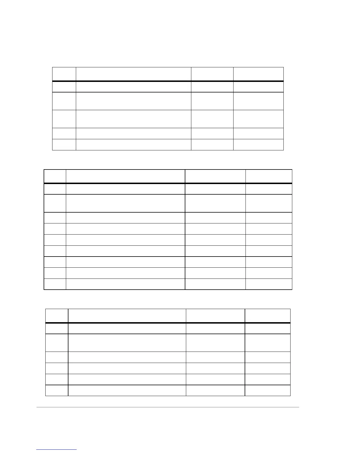
Table 6.68. UDG Structure for Equatorial Mercator
Field Description Range / Name Units
s1 Map projection type EMER n/a
d2 Number of parameters for the selected
projection
3n/a
f3 Longitude for the Central Meridian ±1800000.000
0
dddmmss.sss
f4 False Northing ±10,000,000 meters
f5 False Easting ±10,000,000 meters
Table 6.69. UDG Structure for Transverse Mercator
Field Description Range / Name Units
s1 Map projection type TM83 n/a
d2 Number of parameters for the selected
projection
5 or 7 (last 2 optional) n/a
f3 Longitude for Central meridian ±1800000.0000 dddmmss.ssss
f4 Scale factor at Central Meridian 0.5 to 1.5 n/a
f5 Latitude of the grid origin of the projection ±900000.0000 ddmmss.ssss
f6 False Easting ±10000000 meters
f7 False Northing ±10000000 meters
f8 Zone width (Default is 6°) 3 or 6 degrees
f9 Zone number at 0° longitude (Default is 31°) 1 to 60 N/A
Table 6.70. UDG Structure for Oblique Mercator
Field Description Range / Name Units
s1 Map projection type OM83 n/a
d2 Number of parameters for the selected
projection
6n/a
f3 Azimuth of the skew axis ±1800000.0000 ddmmss.ssss
f4 Scale factor at center of projection 0.5 to 1.5 n/a
f5 Longitude of the grid origin of the projection ±1800000.0000 ddmmss.sss
f6 Latitude of the grid origin of the projection ±900000.0000 ddmmss.sss