NMEA Commands 235
NMEA Commands
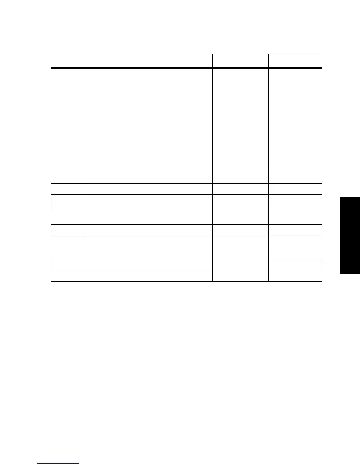
Example full GGA message structure:
$GPGGA,123456.12,1234.123456,N,12345.123456,W,2,12,12.1,12345.1
2,M,-12.1,M,123,1234*7F
Example standard GGA message structure:
$GPGGA,123456.12,1234.12345,N,12345.12345,W,2,12,12.1,12345.1,M
,12,1234*7F
Typical GGA message:
$GPGGA,183805.50,3722.36223,N,12159.82741,W,2,7,2.8, 16.12,M,-
31.24,M,005,0001 *6F
d6 GPS quality indicator
• 0—Invalid position or position not available
• 1—GPS Standard Positioning Service (SPS)
mode (C/A code), fix valid
• 2—Differential GPS, SPS mode, fix valid
• 3—GPS Precise Positioning Service (PPS)
mode (P-code). N/A for DG16
• 4—Real Time Kinematic. System used in RTK
mode with fixed integers. N/A for DG16
• 5—Float RTK. Satellite system used in RTK
mode, floating integers. N/A for DG16
• 6—Estimated (dead reckoning) mode
• 7—Manual input mode
• 8—Simulator mode
0, 1, 2, 6, 7, or 8 0, 1, 2, 6, 7, or 8
d7 Number of satellites used in position computation 3 to 14 3 to 14
d8 HDOP (horizontal dilution of precision) 00.0 to 99.9 00.0 to 99.9
f9 Altitude above Mean Sea Level (geoidal height) -1000.00 to
18000.00
-1000.00 to
18000.00
c10 Altitude unit of measure (always M) M M
d11 Geoidal separation value -999.99 to 999.99 -999.99 to 999.99
c12 Geoidal separation unit of measure (always M) M M
d13 Age of differential corrections (seconds) 0 to 999.999 0 to 99
d14 Differential base station ID number 0 to 1023 0 to 1023
hh Checksum 2-character hex
Table 8.7. $GPGGA Message Format (Continued)
Parameter Description Range (FUL) Range (STD)