Do you have a question about the JRC FF50 and is the answer not in the manual?
Introduction to the JRC color LCD Fish Finder FF50 and its purpose.
Explanation of warning signs used in the manual and on the equipment.
Information regarding the warning label on the unit.
Important warnings and cautions for safe operation and to prevent damage to the unit.
Precautions for safe operation, including handling power and avoiding water exposure.
Guidelines for installing the equipment to avoid operating problems and ensure performance.
Pre-voyage checks to ensure proper operation and identify potential external influences.
Information on suppression ferrites used with JRC equipment.
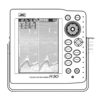
Overview of the FF50 display unit and its controls.
Information on the available transducers for the FF50 unit.
Basic principles of the Color Fish Finder FF50 and its main components.
Details on the display unit, transducer, and optional GPS/DGPS sensors.
List of standard equipment included in the FF50 package.
Details on available transducer models, frequency, and features.
Explanation of the elements displayed on the Fish Finder screen in standard mode.
Guidance on choosing a location and performing standard mounting for the display unit.
Explanation of transducer function and the importance of proper mounting position.
Detailed procedure for installing the transom mount transducer.
Instructions for using the installation template and drilling holes for the bracket.
Recommendations for applying antifouling paint to the transducer to prevent growth.
Instructions for cleaning the sensor and paddlewheel assembly.
Important considerations before installing a thru-hull transducer.
Criteria for choosing the optimal mounting location for thru-hull transducers.
Procedure for connecting GPS/DGPS sensors for navigational data.
Instructions for connecting NMEA0183 data from external navigation equipment.
Fundamental operations including power control and display adjustments.
Mode optimized for fish finding, with automatic range and gain control.
Mode optimized for bottom tracking and normal navigation.
Automatic range and shift control to keep the sea bottom always displayed.
Mode requiring manual operation of all functions.
Setting alerts for fish detection and shallow water conditions.
Setting alerts for deep water, high, and low temperature conditions.
Setting alerts for temperature changes and approaching waypoints.
Setting alerts for anchor drift, deviation from course, and DGPS status.
Enables or disables the buzzer sound for alarm messages.
Standard full screen display for high or low frequency with status indicators.
Using dual frequency, A-Scope, and mixed modes for detailed fish and seabed analysis.
Using VRM Zoom, Auto Zoom, and Bottom Zoom modes for magnified seabed views.
Analyzing seabed conditions and using mixed frequency displays.
Using Graphic (NAV1) and Numeric (NAV2) displays for navigation data.
Navigating to selected waypoints and storing current positions as events.
Following, skipping, and discontinuing route plans for navigation.
Adjusting chart speed and noise suppression levels for display clarity.
Setting interference rejection, STC, and fish symbol display options.
Setting color bars, screen colors, and graph display.
Accessing settings related to the Navigation mode, like waypoints and route plans.
Storing, modifying, copying, and deleting waypoints using the waypoint list.
Creating new route plans by selecting and ordering waypoints.
Changing, inserting, and deleting waypoints within route plans.
Initiates navigation along a selected route plan.
Activates the simulator for practicing operations with dummy data.
Setting the source for water temperature and vessel speed data.
Setting the source for navigation data like position and course.
Adjusting transmission power and selecting EXP Range Mode.
Configuring scales for graphs and units for depth, speed, and temperature.
Calibrating temperature, speed, draft, keel height, and gain settings.
Setting draft and keel height offsets for accurate depth readings.
Adjusting gain offset for in-hull transducers and resetting the trip log.
Setting magnetic variation correction for bearing accuracy.
Configuring general settings for GPS/DGPS sensors.
Configuring settings for the DGPS sensor's beacon receive mode and frequency.
Sends configured GPS/DGPS settings to the sensor.
Advice on keeping equipment clean, checking hardware, and periodic inspections.
Explanation of how sonar technology works for fish finding.
Understanding and recognizing different seabed conditions from display echoes.
Explanation of the Navstar/GPS satellite-based radio navigation system.
How differential GPS works using reference and beacon stations for improved accuracy.
Consulting dealers for advice, and details on warranty and post-warranty repairs.
Importance of periodic maintenance to prevent performance decline and ensure proper operation.
Guidelines for disposing of the LCD module and the fish finder unit.
Instructions for safely handling and disposing of the unit's lithium battery backup.
Schematic diagram illustrating the electrical connections of the unit's components.
List of all parts included in the FF50 unit with their part numbers.
Table listing available geodetic systems for setting GPS/DGPS datum.
List of NMEA0183 input and output sentences used for data communication.
| Brand | JRC |
|---|---|
| Model | FF50 |
| Category | Fish Finder |
| Language | English |