7.13Dchartoverview
The3Dchartprovidesanumberoffeaturestohelpyounavigate
withyourvessel.
Note:Beforeyoucanusethe3Dchartapplicaton,your
multifunctiondisplaymustbereceivingaccurateheadingand
positiondatafromasuitablesource(suchasaGPS,for
example).Youmustalsohave3Dchartcardscontaining3D
cartographyfortheappropriatearea.
Safety
The3Dchartisanaidtovisualization.Whennavigatingwithyour
3Dchartyoushouldalsocheckyour2Dchartandensurethata
routeissafe.Untilyouarefamiliarwithinterpretingthe3Dchart,
youshouldtakeeveryopportunitytocomparethedisplayedobjects
withvisualtargets,suchasbuoysandcoastalstructures.You
shouldpracticeharbourandcoastalnavigationduringdaylightand
inclearweatherconditions.Thesimulatormodecanalsobeused
tohelpyougainexperience.
The3Dapplicationshouldnotbeusedasasubstituteforgood
navigationalpracticenorforofcialgovernmentpapercharts.Do
notusethisapplicationbeforeyouhavereadthischapter.
Usesforthe3DChart
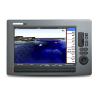
3Dcartographyintroducesaneasy-to-usechartformatthatprovides
youwithathreedimensionalgraphicalviewoflandandsea
contoursaroundyourboat.Landmassesareshowningreen,the
shadedependingontheheightabovesealevel.Water,thesea-bed
andsubmergedobjectsareshowninvaryingshadesofblue.
Muchoftheinformationavailableonaconventionalchartcanbe
showninthreedimensions,givingyouanaccurateeasy-to-view
imageoftheareaaroundyourboatthatcanhelpyouplan:
•Fishingspots.
•Whatshingpatterntouse.
•Saferoutes.
Iftheareathatyouareinisnewtoyou,orvisibilityispoor,3D
cartographycanhelptogiveyouthecondencetoknowwhereyou
areandwhatisaroundyou.Aswithaconventionalchart,active
waypointsandroutescanalsobeshownonthe3Dchart.
86C-SeriesWidescreenuserreference
 Loading...


