7.33Dchartcards
Beforeyoucanusethe3Dchartapplication,youmusthavechart
cardscontainingtheappropriate3Dcartographicdata.
The3Dchartapplicationreliesonappropriatecartographicdata
storedonCompactFlashchartcards.Youmusthavechartcards
containing3Dcartographicdataforthegeographicareainwhich
youwanttonavigateyourvessel.
Chartcardscontainingapproriate3Dcartographicdataareavailable
fromthewww.navionics.comwebsite.
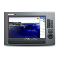
7.43Dchartdisplayoverview
The3Dchartapplicationfeaturesanumberofdisplaymodesto
helpyounavigateyourvessel.
Thefollowingdiagramshowthevariouselementsofthedisplay:
Shows mode
application is
working in.
Rotation
Shows in degrees true,
how far the on-screen
view has been rotated
from your boat's heading.
Range
Horizontal distance across
screen (halfway up the window
or at center of view). Shown in
selected system units.
Boat symbol
Boat's position on
chart. Select sail
or power boat.
Center-of-view
White cross indicates
center of chart view
at sea level.
North arr ow
3D indication of True
North in relation to
the chart view.
Depth scale
Approximate
depth beneath
your boat.
Waypoint
With arrival
circle
Cartogr aphic objects
Select objects for display
via the 3D Chart Setup
menu.
D11602_1
3Dchartviewmodes
Youcanchangetheviewprovidedbythe3Dcharttogiveyoua
betterviewofyoursurroundings.
The3Dchartapplicationhastwomainviewingmodes:
•ActiveMotionmode
•Planningmode
88C-SeriesWidescreenuserreference
 Loading...