Do you have a question about the Simrad NSE12 and is the answer not in the manual?
States liability limitations, governing language, and copyright for the manual.
Invites user feedback for manual improvement via email.
Refers to a separate document for warranty information.
Mentions intended use and refers to an installation manual.
Describes the manual's purpose, assumed user knowledge, and content scope.
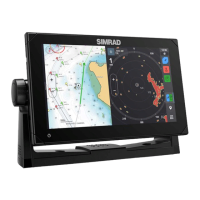
Describes the physical controls and layout of the NSE unit's front panel.
Explains the organization of pages and panels within the NSE display system.
Details how to interact with the NSE system using menus and dialogs.
Instructions for powering the NSE unit on, off, and entering standby mode.
Describes how to set a MOB waypoint in emergency situations.
Explains how to adjust screen and key brightness, including night mode.
Details how to navigate and make selections within the NSE system menus.
Explains how to move and use the cursor on various panels for interaction.
Describes how to input data and text into dialog boxes using the keypad and controls.
Explains how to access, select, and maximize pages and panels on the NSE display.
Details the functionality and controls of the OP40 remote controller for the NSE system.
Explains how to assign control of the NSE units to the OP40 controller.
Explains how to use the simulator to familiarize with the unit before use.
Describes the automatic run-through of the product's main features in demo mode.
Allows configuration of simulator behavior, including source files and GPS settings.
Describes the display and elements of the chart panel for navigation.
Covers cursor use, measurement, positioning, orientation, and detail level.
Details categories, imagery style, overlays, Navionics data, and photo options.
Covers positioning, dialogs, editing, and alarm settings for waypoints.
Explains how the system automatically records vessel tracks and their settings.
Covers creating and editing navigation routes using waypoints.
Describes the library page for managing waypoints, routes, and tracks.
Covers panel layout, operational modes, positioning, and cursor usage.
Details orientation, motion, dual radar, fast scan, STC, optimization, and guard zones.
Explains displaying other vessels, tracking, measuring, EBL/VRM, and radar overlay.
Explains the different symbols used to represent targets on the system.
Details how to configure the display of target information.
Explains the requirement for MMSI numbers to receive addressed messages.
How to create an invisible guard zone to trigger alarms for nearby targets.
Allows configuration of alarms for target proximity, loss, or unavailability.
Describes how to view detailed information about selected targets on the chart.
Explains how to search for other AIS-equipped vessels.
Covers image layout, pausing, setup, and range settings for the echosounder.
Details ping speed, fish echoes, colors, cursor use, measurement, and history viewing.
Covers image optimization, gain/color, noise rejection, and data recording.
Explains access to the panel and describes DownScan and SideScan image types.
Covers changing image, pausing, cursor use, measuring distance, and viewing history.
Details image setup options, noise rejection, and recording StructureScan data.
Covers indication, safe operation, switching modes, locking units, and the autopilot panel.
Details various steering modes and how to select them.
Explains Standby, NFU, FU, and AUTO modes for autopilot operation.
Covers NoDrift, Dodging, and Navigating with the NSE features.
Details initiating turns, variables, and specific turn types like Spiral and Zigzag.
Explains Depth Contour Tracking, Depth Gain, and Contour Cross Angle.
Covers Wind Vane steering, Tacking, Gybing, and prevent functions.
Details wind steering, sailboat parameters, and response tuning.
Explains using the NSE in AP24/AP28 systems, including command transfer.
How to initiate navigation to a cursor position, waypoint, or route.
How to start navigating a route by moving the cursor over it.
How to start route navigation from a specific waypoint.
Describes how to stop active navigation.
Explains methods for distance calculation, alarm limits, variation, datum, and coordinates.
How to navigate between different dashboard layouts.
Describes the predefined dashboard layouts (Vessel, Navigation, Angler).
Explains how to create and add custom dashboards.
Details how to change dashboard styles and gauge data.
Describes configurable screens for presenting live data history in plots.
Details the Time Plot panel layouts for presenting data history.
Explains how to use Sirius audio and weather services via the NSE system.
Displays all available Sirius channels, regardless of subscription status.
How to create a list of favorite channels from the channels list.
How to lock selected channels using an unlock code.
Details how to display weather options as an overlay on the chart.
Explains the use of different icons to represent weather conditions.
How to adjust the opaqueness of the weather overlay.
Explains how color shades indicate sea surface temperature and wave height.
How to set up the system to read forecasts for selected areas or current position.
How to define alarms for severe weather conditions.
Provides a graphic overview of weather condition changes over time.
Describes how to access the CZone panel via the Pages panel.
Explains the one-press functionality for controlling multiple circuits via CZone modes.
Options for monitoring onboard parameters and alarms within the CZone system.
Describes the additional CZone dashboard added to Instrument panels.
How to customize CZone dashboards by changing gauge data.
Lists and displays information about AIS, MARPA, and DSC vessels.
Covers alarms, alarm history, alarm settings, and satellite status.
Includes Find function for chart items and lists for waypoints, routes, and tracks.
Provides access to Trip Log, Sun/Moon data, Tides, and File management.
Explains how to set up pages and panels within page groups.
How to resize panels in multi-panel pages.
How to configure the instrument bar display (off, rows, pages).
How to choose data sources for the instrument bar fields.
Details system-wide settings like language, text size, time, and advanced features.
Classifies alarm messages by color and importance.
Describes how single alarm messages are displayed.
Explains how multiple simultaneous alarms are presented.
Options for acknowledging alarm messages (OK, Disable).
How to configure alarm settings in the Alarms page and access them from Utilities.
Explains how to access and set up the video panel for optional cameras.
Details how to select video source and mirror the video image.
How to adjust video display settings for optimal viewing.
How to select NTSC or PAL video standards for cameras.
Limited maintenance procedures recommended for the NSE unit.
Instructions for cleaning the display and checking keys and connectors.
Recommends regularly exporting system files (waypoints, settings) to a memory stick.
Provides an overview of the various system settings menus available.
Explains how context menus provide relevant options for the active panel.
Describes how to initiate navigation functions from the Goto menu.
Details how to create waypoints, routes, and tracks using the Plot menu.
| Display Size | 12.1 inches |
|---|---|
| Resolution | 1280 x 800 pixels |
| Touchscreen | Yes |
| Voltage | 12/24V DC |
| Display Type | TFT LCD |
| Operating Temperature | -15°C to +55°C |