9.10Tideinformation
Animatedtideinformation
Theelectronicchartsmayallowanimationofthetideinformation
tidestations.
Animatedcurrentinformationisavailableinthechartapplication
whereveradiamond-shapedsymbolwitha"T"isdisplayed:
Thissymbolidentiestidestationsandtheavailabilityoftide
informationforthelocation.
Whenyouselectatidestationsymbolthechartcontextmenuis
displayed,whichprovidestheAnimateoption.
WhenyouselectAnimatetheanimatemenuisdisplayedandthe
diamond–shapedsymbolsarereplacedwithdynamictidebarwhich
indicatesthepredictedtideheightfortheactualtimeanddate:
Tideanimation.
•Tideheightisindicatedbyagauge.Thegaugeiscomprised
of8levels,whicharesetaccordingtotheabsoluteminimum/
maximumvaluesofthatparticularday.
•Thecolorofthearrowonthetidegaugesindicateschangesin
thetideheight:
–Red:increasingtideheight.
–Blue:decreasingtideheight.
Theanimationcanbeviewedcontinuouslyorincrementallyata
timeintervalthatyouspecify.Youcanalsosetthedateforthe
animation,andstartorrestarttheanimationatanypointwithina
24-hourperiod.Ifthesystemdoesnothaveavaliddateandtime
thedateusedwillbemiddayforthesystemdefaultdate.
Note:Notallelectronicchartssupporttheanimatedtidesfeature.
Viewinganimatedtideinformation
Fromthechartapplication:
1.Selectdiamond-shapedtideicon.
Thechartcontextmenuisdisplayed.
2.SelectAnimate.
Theanimatemenuisdisplayedandthetideiconisreplacedwith
adynamictidebarindicator.
Controllinganimations
Fromthechartapplication,withtheanimatemenudisplayed:
1.Tostartorstoptheanimation,selectAnimate:toswitch
betweenPlayandPause.
2.Toviewtheanimationinsteps,selectStepBackorStep
Forward.
3.Tosettheanimationstepinterval,pauseanyplayinganimations,
andthenselectSetTimeInterval.
4.Tosettheanimationdate,selectSetDateandthenusingtheon
screenkeyboardentertherequireddate.
5.TosettheanimationdatetothecurrentdateselectToday.
6.Tosettheanimationdateto24hoursprevioustothecurrent
dateselectPreviousDate.
7.Tosettheanimationdateto24hoursaheadofthecurrentdate
selectNextDay.
Displayingdetailsoftides
Fromthechartapplication:
1.Selectdiamond-shapedtideicon.
Thechartcontextmenuisdisplayed.
2.SelectTideStation.
Thetidegraphfortheselectedtidestationisdisplayed.
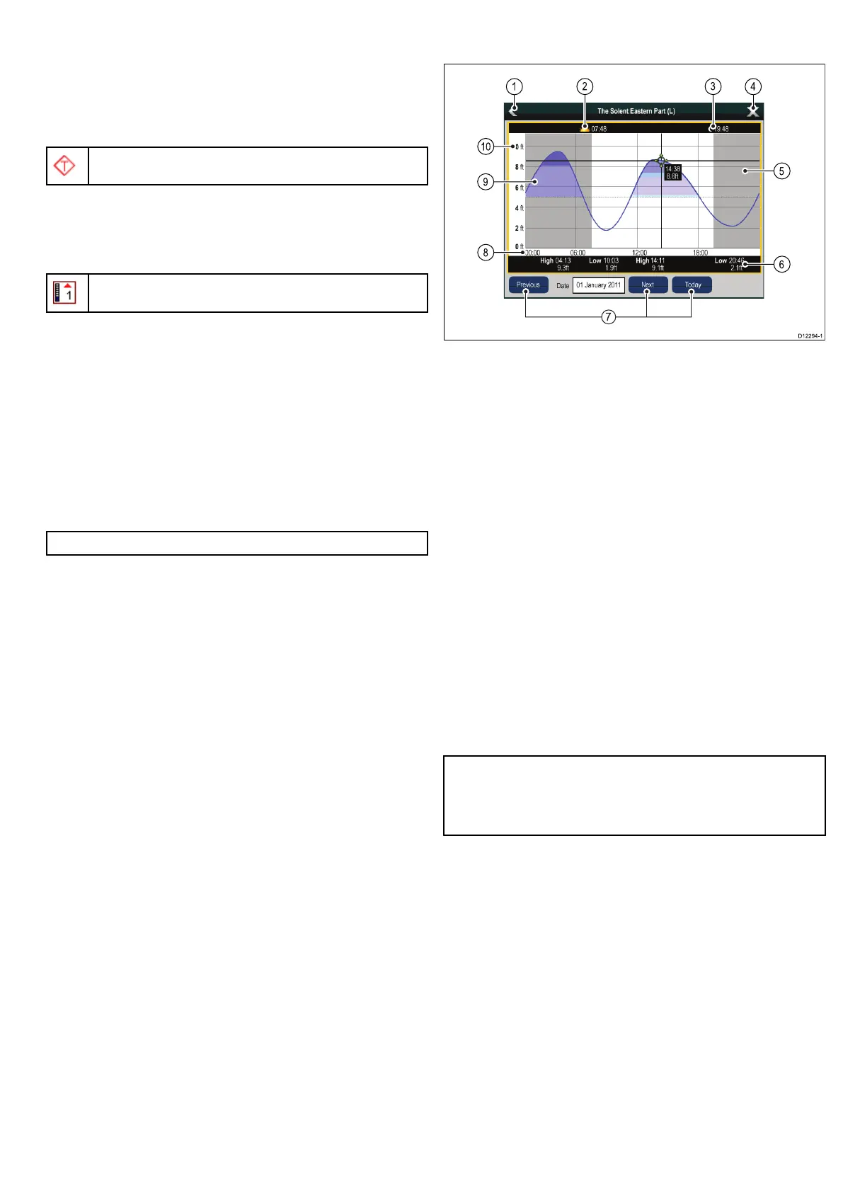
Tidegraphs
Tidegraphsprovideagraphicalviewoftidalactivity.
1.Back—returntothepreviousmenuorview.
2.Sunriseindicator—indicateswhenthesunrises.
3.Sunsetindicator—indicateswhenthesunsets.
4.Exit—closesthedialog.
5.Nightfallindicator—thegreyed-outsectionofthegraph
indicateswhennightfalloccurs.
6.Low/HighTide—Indicatesthetimeatwhichloworhightide
occurs.
7.Datenavigation—Usetheiconstomovetothenextor
previousday.
8.Time—Thehorizontalaxisofthegraphindicatestime,in
accordancewiththetimeformatspeciedintheSystem
Settings.
9.Minimumsafedepth—Theblueshadedareaofthegraph
indicatesthepointduringthetidecyclewhenitissafeto
navigateyourvessel,basedonthewaterdepthatthattime
andthesettingsyouspeciedforyourvesselintheMinimum
SafeDepthsettingsintheCustomizemenu.Forexample,the
diagramaboveisbasedonaminimumsafedepthsettingof5ft.
10.Depth—Theverticalaxisofthegraphindicatestidalwater
depth.Theunitsforthedepthmeasurementarebasedonthose
speciedintheHomescreen>Customize>UnitsSet-up>
DepthUnitsmenu.
Note:Thedataprovidedinthetidegraphsisforinformation
purposesonlyandshouldNOTberelieduponasasubstitutefor
prudentnavigation.Onlyofcialgovernmentchartsandnotices
tomarinerscontainallthecurrentinformationneededforsafe
navigation.Alwaysmaintainapermanentwatch.
Usingthechart
105
 Loading...


