Groundtripresetsmenu
Thismenuenablesyoutoresetsthechosengroundtripdistancecountertozero.
MenuitemDescription
GroundTrip1Reset
Resetsthegroundtrip1distancecountertozero.
GroundTrip2Reset
Resetsthegroundtrip2distancecountertozero.
GroundTrip3Reset
Resetsthegroundtrip3distancecountertozero.
GroundTrip4Reset
Resetsthegroundtrip4distancecountertozero.
Systemsettingsmenu
GPSsetup
TheGPSsetupoptionsenableyoutocongureaconnectedGPS
receiver.
TheGlobalPositioningSystem(GPS)isusedtopositionyourvessel
onthechart.YoucansetupyourGPSreceiverandcheckitsstatus
fromtheGPSStatusoptionintheSystemSettingsmenu.For
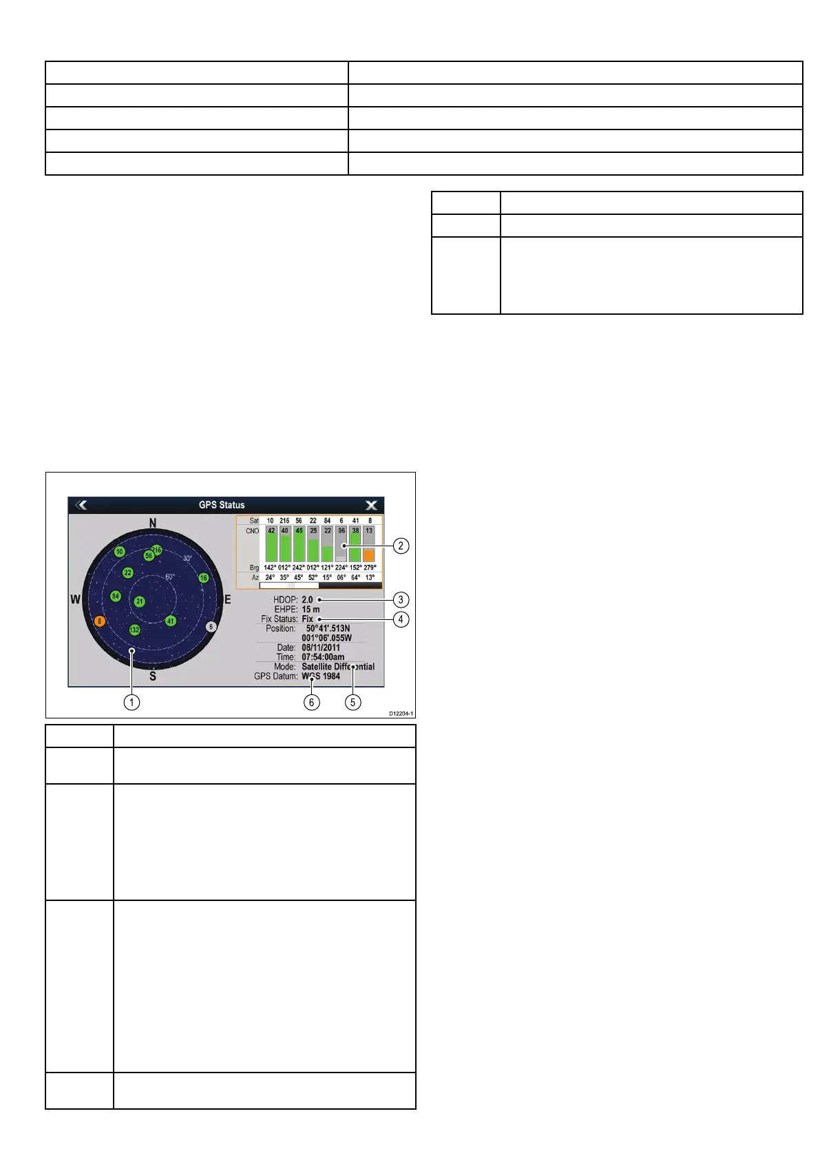
eachtrackedsatellite,thescreenprovidesthefollowinginformation:
•Satellitenumber.
•Signalstrengthbar.
•Status.
•Azimuthangle.
•Elevationangle.
•Asky-viewtoshowthepositionoftrackedsatellites.
ItemDescription
1
Skyview—avisualrepresentationofthepositionoftracked
satellites.
2
Satellitestatus—displaysthesignalstrengthandstatusof
eachsatelliteidentiedintheskyviewdiagramontheleftofthe
screen.Thecoloredbarshavethefollowingmeanings:
•Grey=searchingforsatellite.
•Green=satelliteinuse.
•Orange=trackingsatellite.
3
HorizontalDilutionofPosition(HDOP)—ameasureof
GPSaccuracy,calculatedfromanumberoffactorsincluding
satellitegeometry,systemerrorsinthedatatransmissionand
systemerrorsintheGPSreceiver.Ahigherguresigniesa
greaterpositionalerror.AtypicalGPSreceiverhasanaccuracy
ofbetween5and15m.Asanexample,assumingaGPS
receivererrorof5m,anHDOPof2wouldrepresentanerror
ofapproximately15m.Pleaserememberthatevenavery
lowHDOPgureisNOguaranteethatyourGPSreceiveris
providinganaccurateposition.Ifindoubt,checkthedisplayed
vesselpositioninthechartapplicationagainstyouractual
proximitytoaknownchartedobject.
4
Fixstatus—indicatestheactualmodetheGPSreceiveris
reporting(NoFix,Fix,DFixorSDFix).
ItemDescription
5
Mode—themodecurrentlyselectedbytheGPSreceiver.
6
Datum—TheGPSreceiver’sdatumsettingaffectsthe
accuracyofthevesselpositioninformationdisplayedinthechart
application.InorderforyourGPSreceiverandmultifunction
displaytocorrelateaccuratelywithyourpapercharts,theymust
beusingthesamedatum.
TheaccuracyoftheGPSreceiverdependsontheparameters
detailedabove,especiallytheazimuthandelevationangleswhich
areusedintriangulationtocalculateyourposition.
Multipledatasources(MDS)overview
Installationsthatincludemultipleinstancesofdatasourcescan
causedataconicts.Anexampleisaninstallationfeaturingmore
thanonesourceofGPSdata.
MDSenablesyoutomanageconictsinvolvingthefollowingtypes
ofdata:
•GPSPosition.
•Heading.
•Depth.
•Speed.
•Wind.
Typicallythisexerciseiscompletedaspartoftheinitialinstallation,
orwhennewequipmentisadded.
IfthisexerciseisNOTcompletedthesystemwillautomatically
attempttoresolvedataconicts.However,thismayresultinthe
systemchoosingasourceofdatathatyoudonotwanttouse.
IfMDSisavailablethesystemcanlisttheavailabledatasources
andallowyoutoselectyourpreferreddatasource.ForMDStobe
availableallproductsinthesystemthatusethedatasourceslisted
abovemustbeMDS-compliant.Thesystemcanlistanyproducts
thatareNOTcompliant.Itmaybenecessarytoupgradethe
softwareforthesenon-compliantproductstomakethemcompliant.
VisittheRaymarinewebsite(www.raymarine.com)toobtainthe
latestsoftwareforyourproducts.IfMDS-compliantsoftwareisnot
availableandyoudoNOTwantthesystemtoautomaticallyattempt
toresolvedataconicts,anynon-compliantproduct(s)canbe
removedorreplacedtoensuretheentiresystemisMDS-compliant.
Customizingyourdisplay
229
 Loading...


