Reference
Avidyne EX500/EX600 MFD -140- 600-00078-001 Rev 05
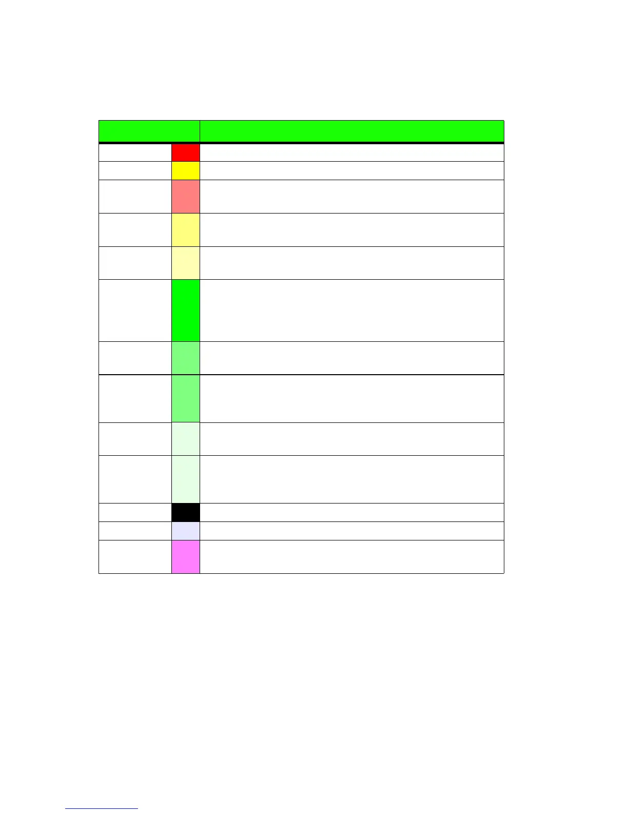
11.6 TAWS Display Color Coding
Table 11.1 EGPWS Display Color Formats
Color Meaning
Solid Red Terrain/Obstacle threat area, a warning is generated.
Solid Yellow
Terrain/Obstacle threat area, a caution is generated.
50% Red
Dots
Terrain/Obstacle that is more than 2,000 feet above
aircraft.
50% Yellow
Dots
Terrain/Obstacle that is between 1,000 and 2,000 feet
above aircraft.
25% Yellow
Dots
Terrain/Obstacle that is 500 (250 with gear down) feet
below to 1,000 feet above aircraft altitude.
Solid Green
Peaks only. Shown only when no Red or Yellow Terrain/
Obstacle areas are within range on the display. Highest
Terrain/Obstacle not within 500 (250 with gear down)
feet of aircraft altitude.
50% Green
Dots
Terrain/Obstacle that is 500 (250 with gear down) feet
below to 1,000 feet below aircraft altitude.
50% Green
Dots
Peaks only. Terrain/Obstacle that is the middle
elevation band when there is no Red or Yellow terrain
areas within range on the display.
16% Green
Dots
Terrain/Obstacle that is 1,000 to 2,000 feet below aircraft
altitude.
16% Green
Dots
Peaks only. Terrain/Obstacle that is the lower elevation
band when there is no Red or Yellow terrain areas within
range on the display.
Black No significant terrain/obstacle.
16% Blue
Peaks only. Water at sea level elevation (0 feet MSL).
Magenta
Dots
Unknown terrain. No terrain data in the data base for the
magenta area shown.