Chapter 5 _________________________________________________________ Theory of Operation
VAISALA _______________________________________________________________________ 149
Present Weather
Precipitation Types
The ratio of the optical intensity and the RAINCAP
®
intensity estimates
are the key factors used in defining the precipitation type (see section
Precipitation Intensity on page 148). Some filtering is used in calculating
the intensity ratio to get the parameter that is used in the type finding
procedure. The Weather delay parameter is also used in eliminating
unrealistic changes in the precipitation type. The sensor cross arm
temperature TS is used in selecting the default precipitation type. The
default precipitation type is rain when the temperature is above +6 °C.
The default is snow when the temperature is below -0 °C and between -
0 °C and +6 °C the default is unknown (P or 40).
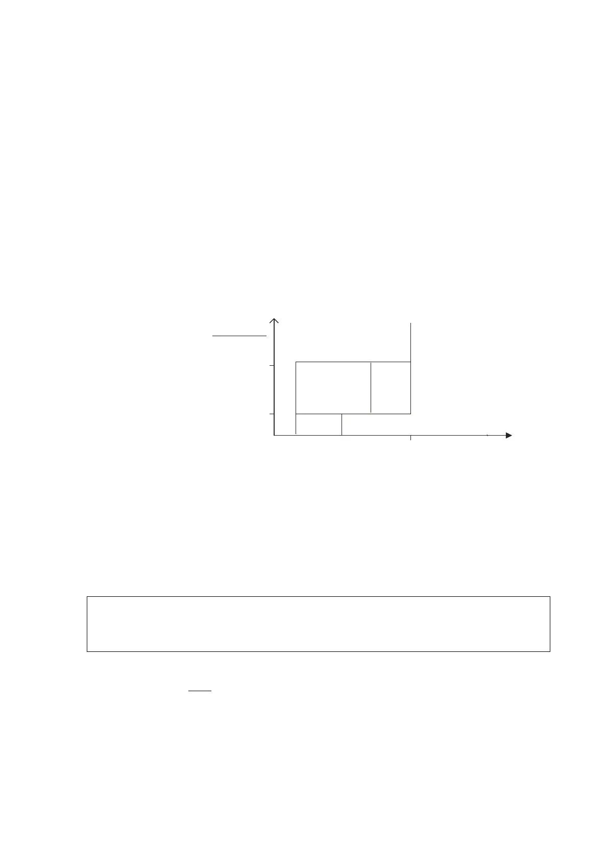
Snow
Ratio
Optical Intensity
DRD Intensity
Snow limit
(default=5)
Rain
Rain
Freezing
Rain
Ice Pellets
Rain and Snow
or
1
-8ºC 0ºC +6ºC
Snow
and
Temperature (TS)
0403-104
Figure 45 Principle for Determining Precipitation Type
Liquid Precipitation
In liquid precipitation the optical and the RAINCAP
®
intensities are near
each other, or the RAINCAP
®
intensity is higher. Rain and drizzle are
separated by the highest peak signal (largest droplet). If liquid
precipitation is detected below 0 °C (TS), it is indicated as freezing rain
or freezing drizzle (ZR, ZL)
NOTE
freezing precipitation detection is based on the practical
definition of "rain (or drizzle) freez
ing on surfaces", not on detecting
Rain
If the maximum droplet size is bigger than the Drizzle limit, the
precipitation type is rain. Light rain limit and Heavy rain limit are the
(approx.) two-minute average intensity limits in mm/h, which are used in
setting the rain intensity type.