18.9Chartviews
Ifsupportedbyyourcartographytype,theChart
applicationcanbesettoeither2Dor3Dview.
Selecting2Dand3Dchartviews
Youcanswitchbetween2Dand3Dviewsinthe
chartapplicationifsupportedbyyourcartography.
Fromthechartapplicationmenu:
1.SelectPresentation.
2.SelectView&Motion.
3.SelectChartViewtoselect2Dor3D.
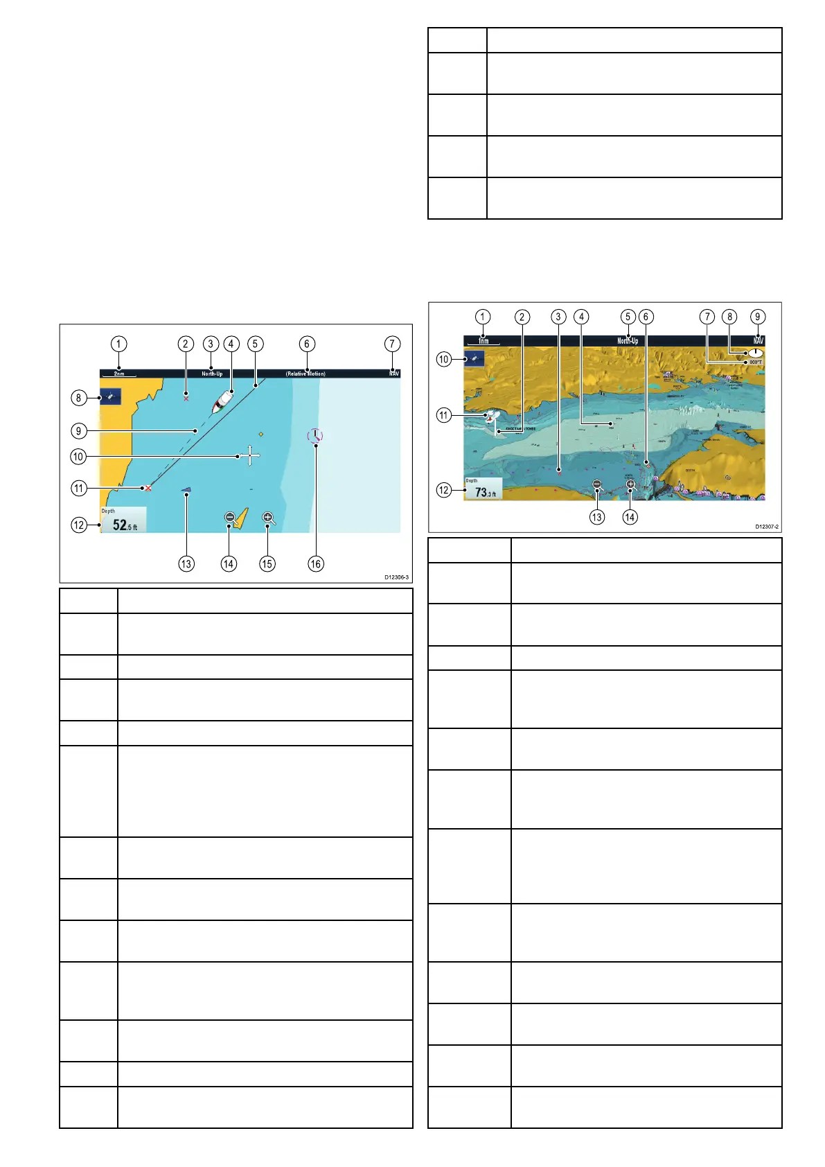
2Dchartview
The2Dchartviewcandisplayarangeofinformation
tohelpyounavigate.
D12306-3
1 2 3 6 74 5
14 15 16
13
8
11
9
10
12
ItemDescription
1
Range—horizontalchartscaleindicator(shownin
selectedsystemunits).
2Waypoint—inactive.
3
Orientation—statestheorientationmodethatthe
chartisusing(North-up,Head-up,orCourse-up).
4Vesselsymbol—showsyourcurrentposition.
5
Navigationoriginline—duringnavigation,shows
asolidlinefromthestartingpointtothetarget
waypoint.Thestartingpointcanbethevessel’s
originallocation,thepointofXTEresetorthepoint
thecurrentlegofaroutewasinitiated.
6Motionmode—statesthecurrentmotionmode
(Relative,True,orAutoRange).
7
Charttype—indicatesthetypeofchartinuse—
FishorNavigation.
8
Findshipicon—usedtondandcenteryour
vesselonthechart.
9Vesselpositionline—duringnavigation,shows
adottedlinefromthevessel’scurrentpositionto
thetargetwaypoint.
10
Cursor—usedtoselectchartobjectsandmove
aroundthechartarea.
11Targetwaypoint—currenttargetwaypoint.
12Databoxes—usedtodisplaydatasuchasdepth
onthechartscreen.
ItemDescription
13
AIStarget—avesselbroadcastingAISinformation
(optional).
14
Rangeout—selecticontorangeout(Touchscreen
displaysonly).
15
Rangein—selecticontorangein(Touchscreen
displaysonly).
16
Cartographicobjects—levelofcartographic
objectsisdeterminedbythecartographytype.
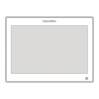
3Dchartview
The3Dviewcandisplayarangeofinformationto
helpyounavigate.
00°T
1 5 6 9
10
11
12
3
2
84 7
1413
D12307-2
ItemDescription
1Range—horizontalchartscaleindicator
(showninselectedsystemunits).
2
DepthScale—approximatedepthbeneath
yourvessel(optional).
3Waypoint—optional.
4
Center-of-view—thewhitecrossindicates
thecenterofchartviewatthewaterlevel
(optional).
5
Orientation—statestheorientationmode
thatthechartisusing.
6
Cartographicobjects—usetheCartography
Set-upmenutochoosewhichobjectsto
display.
7
Rotation—showsindegreestrue,howfar
theon-screenviewhasbeenrotatedfromyour
vessel'sheadingandthetiltangleofyour
vessel.
8
Northarrow–3DindicationofTrueNorthin
relationtothechartview.Thenortharrowalso
tiltstoindicatepitchangle.
9
Charttype—indicatesthetypeofchartinuse
—FishorNavigation.
10
Findshipicon—usedtondandcenteryour
vesselonthechart.
11Vesselsymbol—yourvessel'scurrent
position.
12Dataoverlay—usedtodisplaydatasuchas
depthonthechartscreen.
Chartapplication
243



 To Next Page