LIMITATIONS
© 2017 Intel Corporation. All rights reserved. 21
REV 00
APR 2017
The short-term accuracy is usually
higher, because of the data fusion
with other available sensor output
from the Inertial Measurement Unit
(IMU).
Vertical accuracy of GPS is lower
and the measured altitude can vary
up to 49 ft. (15 m) depending on
satellite constellation.
A barometric measurement is used
for altitude instead of relying on
GPS. Height is always measured
above ground level and is reset to
zero when the Propellers are being started.
Throughout the duration of a mission there can be a drift of +/- 16 ft. (5 m) due to all possible
errors such as temperature, drift, weather changes, etc.
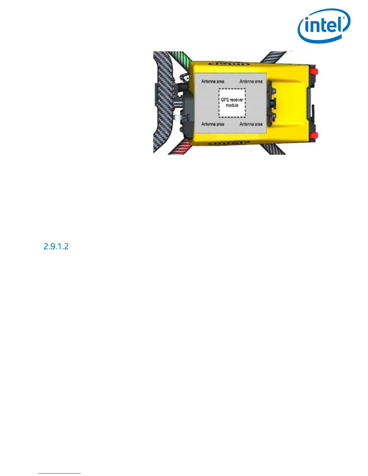
The GPS receiver module of the Intel
®
Falcon™ 8+ UAS is placed directly underneath the canopy
of the central unit and is surrounded by an antenna. The canopy of the Intel
®
Falcon™ 8+ UAS is
made from a material which does not influence the satellite signals, but anything on the top of
the Intel
®
Falcon™ 8+ UAS can potentially disturb the signal. Never cover the GPS receiver
module nor the antenna area to ensure best possible GPS reception.
Shadowing
The position accuracy can be impaired when obstacles block the direct line-of-sight from many
satellites. The obstacle virtually casts a Global Navigation Satellite Systems (GNSS)-shadow
over the concerned area. This results in fewer received satellite signals and a changed geometry
of the signals themselves. This effect is very common in urban areas, where satellites can be
blocked by tall buildings.
If the UAS moves out of the shadow and more satellite signals can be used to calculate the
position, the UAS can suddenly change its position due to the new calculation. Therefore, the
pilot needs to pay special attention in such situations. Whenever there are potential shadings
of the GPS signal, it is recommended to not use GPS-Mode but instead to activate Height-Mode
on the Intel
®
Cockpit GCS.
When the Intel
®
Falcon™ 8+ UAS detects a low GPS quality, it automatically activates HeightMode
and gives the respective warning GPS lost.
It is strongly recommended to actively switch to Height-Mode on the Intel
®
Cockpit GCS before
it is automatically activated because it is unpredictable when the system will switch between
flight modes. Additionally, the system might only switch to Height-Mode, when the positional
accuracy is already low for the current flight situation.